You are here: Home > Network List > UW - Pacific Northwest Regional Seismic Network Stations List
> Station LEBA Lebam, WA, USA > Earthquake Result Viewer
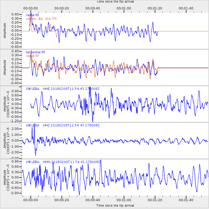
LEBA Lebam, WA, USA - Earthquake Result Viewer
*The percent match for this event was below the threshold and hence no stack was calculated.
| Earthquake location: |
Fiji Islands Region |
| Earthquake latitude/longitude: |
-17.9/-178.7 |
| Earthquake time(UTC): |
2018/02/09 (040) 11:43:56 GMT |
| Earthquake Depth: |
545 km |
| Earthquake Magnitude: |
5.9 Mww |
| Earthquake Catalog/Contributor: |
NEIC PDE/us |
|
| Network: |
UW Pacific Northwest Regional Seismic Network |
| Station: |
LEBA Lebam, WA, USA |
| Lat/Lon: |
46.55 N/123.56 W |
| Elevation: |
73 m |
|
| Distance: |
81.1 deg |
| Az: |
34.961 deg |
| Baz: |
232.24 deg |
| Ray Param: |
$rayparam |
*The percent match for this event was below the threshold and hence was not used in the summary stack. |
|
| Radial Match: |
49.527214 % |
| Radial Bump: |
400 |
| Transverse Match: |
63.809597 % |
| Transverse Bump: |
400 |
| SOD ConfigId: |
13570011 |
| Insert Time: |
2019-04-29 18:42:36.541 +0000 |
| GWidth: |
2.5 |
| Max Bumps: |
400 |
| Tol: |
0.001 |
|
Signal To Noise
| Channel | StoN | STA | LTA |
| UW:LEBA: :HHZ:20180209T11:54:43.278008Z | 4.5497665 | 1.118353E-6 | 2.4580447E-7 |
| UW:LEBA: :HHN:20180209T11:54:43.278008Z | 1.1802008 | 2.888436E-7 | 2.4474105E-7 |
| UW:LEBA: :HHE:20180209T11:54:43.278008Z | 1.1333722 | 3.603345E-7 | 3.1793127E-7 |
| Arrivals |
| Ps | |
| PpPs | |
| PsPs/PpSs | |


