You are here: Home > Network List > TA - USArray Transportable Network (new EarthScope stations) Stations List
> Station X14A Yava, AZ, USA > Earthquake Result Viewer
X14A Yava, AZ, USA - Earthquake Result Viewer
| Earthquake location: |
Near Coast Of Peru |
| Earthquake latitude/longitude: |
-13.4/-76.6 |
| Earthquake time(UTC): |
2007/08/15 (227) 23:40:57 GMT |
| Earthquake Depth: |
39 km |
| Earthquake Magnitude: |
6.7 MB, 7.9 MS, 8.0 MW, 7.5 ME |
| Earthquake Catalog/Contributor: |
WHDF/NEIC |
|
| Network: |
TA USArray Transportable Network (new EarthScope stations) |
| Station: |
X14A Yava, AZ, USA |
| Lat/Lon: |
34.47 N/112.89 W |
| Elevation: |
1078 m |
|
| Distance: |
58.8 deg |
| Az: |
325.121 deg |
| Baz: |
137.656 deg |
| Ray Param: |
0.06255283 |
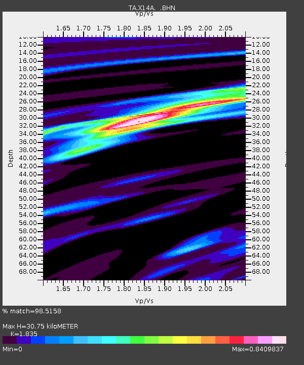
| Estimated Moho Depth: |
30.75 km |
| Estimated Crust Vp/Vs: |
1.84 |
| Assumed Crust Vp: |
6.276 km/s |
| Estimated Crust Vs: |
3.42 km/s |
| Estimated Crust Poisson's Ratio: |
0.29 |
|
| Radial Match: |
98.5158 % |
| Radial Bump: |
205 |
| Transverse Match: |
89.10508 % |
| Transverse Bump: |
400 |
| SOD ConfigId: |
2564 |
| Insert Time: |
2010-03-06 08:51:54.788 +0000 |
| GWidth: |
2.5 |
| Max Bumps: |
400 |
| Tol: |
0.001 |
|

Signal To Noise
| Channel | StoN | STA | LTA |
| TA:X14A: :BHN:20070815T23:50:21.324021Z | 10.07242 | 7.1212025E-7 | 7.070002E-8 |
| TA:X14A: :BHE:20070815T23:50:21.324021Z | 9.497457 | 6.647401E-7 | 6.999139E-8 |
| TA:X14A: :BHZ:20070815T23:50:21.324021Z | 24.708 | 1.9923673E-6 | 8.0636525E-8 |
| Arrivals |
| Ps | 4.3 SECOND |
| PpPs | 13 SECOND |
| PsPs/PpSs | 18 SECOND |


