You are here: Home > Network List > TA - USArray Transportable Network (new EarthScope stations) Stations List
> Station X14A Yava, AZ, USA > Earthquake Result Viewer
X14A Yava, AZ, USA - Earthquake Result Viewer
| Earthquake location: |
Tonga Islands |
| Earthquake latitude/longitude: |
-21.3/-174.7 |
| Earthquake time(UTC): |
2006/11/30 (334) 11:33:17 GMT |
| Earthquake Depth: |
14 km |
| Earthquake Magnitude: |
5.7 MB, 6.1 MS, 6.0 MW, 6.0 MW |
| Earthquake Catalog/Contributor: |
WHDF/NEIC |
|
| Network: |
TA USArray Transportable Network (new EarthScope stations) |
| Station: |
X14A Yava, AZ, USA |
| Lat/Lon: |
34.47 N/112.89 W |
| Elevation: |
1078 m |
|
| Distance: |
80.7 deg |
| Az: |
47.531 deg |
| Baz: |
236.364 deg |
| Ray Param: |
0.04806136 |
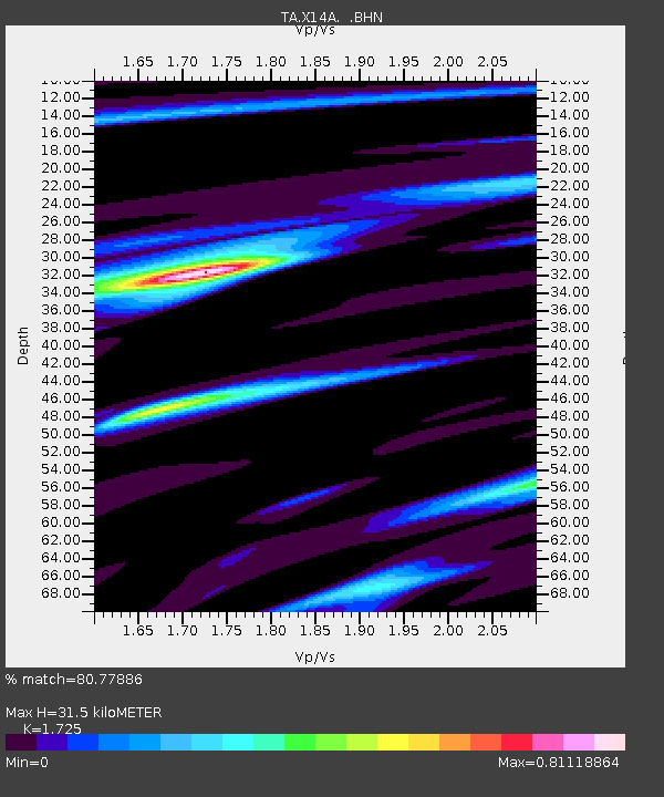
| Estimated Moho Depth: |
31.5 km |
| Estimated Crust Vp/Vs: |
1.73 |
| Assumed Crust Vp: |
6.276 km/s |
| Estimated Crust Vs: |
3.638 km/s |
| Estimated Crust Poisson's Ratio: |
0.25 |
|
| Radial Match: |
80.77886 % |
| Radial Bump: |
267 |
| Transverse Match: |
47.04405 % |
| Transverse Bump: |
400 |
| SOD ConfigId: |
2564 |
| Insert Time: |
2010-03-06 08:52:42.106 +0000 |
| GWidth: |
2.5 |
| Max Bumps: |
400 |
| Tol: |
0.001 |
|

Signal To Noise
| Channel | StoN | STA | LTA |
| TA:X14A: :BHN:20061130T11:44:58.449016Z | 0.98604715 | 1.5891851E-7 | 1.6116725E-7 |
| TA:X14A: :BHE:20061130T11:44:58.449016Z | 1.0015389 | 1.2789626E-7 | 1.2769974E-7 |
| TA:X14A: :BHZ:20061130T11:44:58.449016Z | 2.9189086 | 3.927998E-7 | 1.3457077E-7 |
| Arrivals |
| Ps | 3.7 SECOND |
| PpPs | 13 SECOND |
| PsPs/PpSs | 17 SECOND |


