You are here: Home > Network List > LD - Lamont-Doherty Cooperative Seismographic Network Stations List
> Station BMNY Brushton-Moira, New York > Earthquake Result Viewer
BMNY Brushton-Moira, New York - Earthquake Result Viewer
| Earthquake location: |
Near Coast Of Jalisco, Mexico |
| Earthquake latitude/longitude: |
18.9/-104.8 |
| Earthquake time(UTC): |
2018/02/09 (040) 14:05:47 GMT |
| Earthquake Depth: |
10 km |
| Earthquake Magnitude: |
5.8 Mww |
| Earthquake Catalog/Contributor: |
NEIC PDE/us |
|
| Network: |
LD Lamont-Doherty Cooperative Seismographic Network |
| Station: |
BMNY Brushton-Moira, New York |
| Lat/Lon: |
44.84 N/74.51 W |
| Elevation: |
115 m |
|
| Distance: |
36.1 deg |
| Az: |
37.482 deg |
| Baz: |
234.08 deg |
| Ray Param: |
0.07686036 |
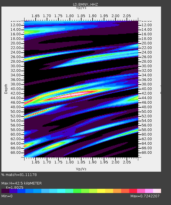
| Estimated Moho Depth: |
42.5 km |
| Estimated Crust Vp/Vs: |
1.80 |
| Assumed Crust Vp: |
6.419 km/s |
| Estimated Crust Vs: |
3.561 km/s |
| Estimated Crust Poisson's Ratio: |
0.28 |
|
| Radial Match: |
81.11178 % |
| Radial Bump: |
400 |
| Transverse Match: |
53.84233 % |
| Transverse Bump: |
400 |
| SOD ConfigId: |
13570011 |
| Insert Time: |
2019-04-29 18:47:22.257 +0000 |
| GWidth: |
2.5 |
| Max Bumps: |
400 |
| Tol: |
0.001 |
|

Signal To Noise
| Channel | StoN | STA | LTA |
| LD:BMNY: :HHZ:20180209T14:12:18.125004Z | 2.3066292 | 4.773866E-7 | 2.0696288E-7 |
| LD:BMNY: :HHN:20180209T14:12:18.125004Z | 1.38072 | 2.1706184E-7 | 1.5720916E-7 |
| LD:BMNY: :HHE:20180209T14:12:18.125004Z | 1.3632407 | 3.2628895E-7 | 2.3934803E-7 |
| Arrivals |
| Ps | 5.7 SECOND |
| PpPs | 17 SECOND |
| PsPs/PpSs | 23 SECOND |


