You are here: Home > Network List > TA - USArray Transportable Network (new EarthScope stations) Stations List
> Station X14A Yava, AZ, USA > Earthquake Result Viewer
X14A Yava, AZ, USA - Earthquake Result Viewer

| Earthquake location: |
Panama-Costa Rica Border Region |
| Earthquake latitude/longitude: |
8.2/-82.9 |
| Earthquake time(UTC): |
2006/05/01 (121) 07:47:59 GMT |
| Earthquake Depth: |
13 km |
| Earthquake Magnitude: |
5.1 MB, 5.6 MS, 5.9 MW, 5.9 MW |
| Earthquake Catalog/Contributor: |
WHDF/NEIC |
|
| Network: |
TA USArray Transportable Network (new EarthScope stations) |
| Station: |
X14A Yava, AZ, USA |
| Lat/Lon: |
34.47 N/112.89 W |
| Elevation: |
1078 m |
|
| Distance: |
38.0 deg |
| Az: |
317.869 deg |
| Baz: |
126.503 deg |
| Ray Param: |
0.075794786 |
| Estimated Moho Depth: |
33.75 km |
| Estimated Crust Vp/Vs: |
1.64 |
| Assumed Crust Vp: |
6.276 km/s |
| Estimated Crust Vs: |
3.827 km/s |
| Estimated Crust Poisson's Ratio: |
0.20 |
|
| Radial Match: |
84.46187 % |
| Radial Bump: |
300 |
| Transverse Match: |
73.08567 % |
| Transverse Bump: |
400 |
| SOD ConfigId: |
2669 |
| Insert Time: |
2010-03-06 08:53:43.113 +0000 |
| GWidth: |
2.5 |
| Max Bumps: |
400 |
| Tol: |
0.001 |
|
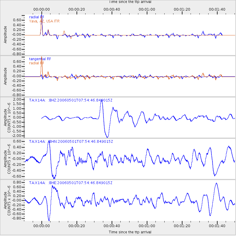
Signal To Noise
| Channel | StoN | STA | LTA |
| TA:X14A: :BHN:20060501T07:54:46.849015Z | 3.7747738 | 3.0503392E-7 | 8.0808526E-8 |
| TA:X14A: :BHE:20060501T07:54:46.849015Z | 3.3773682 | 3.9658568E-7 | 1.1742448E-7 |
| TA:X14A: :BHZ:20060501T07:54:46.849015Z | 7.5421886 | 8.920379E-7 | 1.18273086E-7 |
| Arrivals |
| Ps | 3.7 SECOND |
| PpPs | 13 SECOND |
| PsPs/PpSs | 17 SECOND |


