You are here: Home > Network List > TA - USArray Transportable Network (new EarthScope stations) Stations List
> Station X14A Yava, AZ, USA > Earthquake Result Viewer
X14A Yava, AZ, USA - Earthquake Result Viewer

| Earthquake location: |
Eastern Siberia, Russia |
| Earthquake latitude/longitude: |
61.4/167.5 |
| Earthquake time(UTC): |
2006/04/21 (111) 11:14:15 GMT |
| Earthquake Depth: |
12 km |
| Earthquake Magnitude: |
5.8 MB, 5.8 MS, 6.1 MW, 6.1 MW |
| Earthquake Catalog/Contributor: |
WHDF/NEIC |
|
| Network: |
TA USArray Transportable Network (new EarthScope stations) |
| Station: |
X14A Yava, AZ, USA |
| Lat/Lon: |
34.47 N/112.89 W |
| Elevation: |
1078 m |
|
| Distance: |
55.6 deg |
| Az: |
80.183 deg |
| Baz: |
324.921 deg |
| Ray Param: |
0.06471297 |
| Estimated Moho Depth: |
28.5 km |
| Estimated Crust Vp/Vs: |
1.77 |
| Assumed Crust Vp: |
6.276 km/s |
| Estimated Crust Vs: |
3.546 km/s |
| Estimated Crust Poisson's Ratio: |
0.27 |
|
| Radial Match: |
92.48456 % |
| Radial Bump: |
308 |
| Transverse Match: |
76.81995 % |
| Transverse Bump: |
400 |
| SOD ConfigId: |
2669 |
| Insert Time: |
2010-03-06 08:53:44.729 +0000 |
| GWidth: |
2.5 |
| Max Bumps: |
400 |
| Tol: |
0.001 |
|
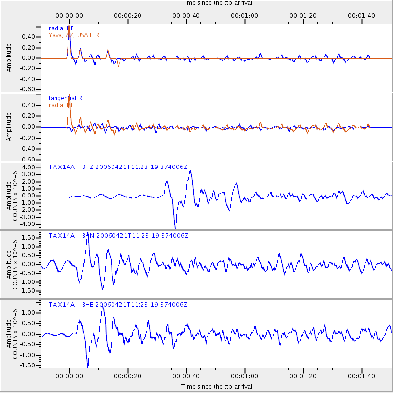
Signal To Noise
| Channel | StoN | STA | LTA |
| TA:X14A: :BHN:20060421T11:23:19.374006Z | 3.2105465 | 4.3949012E-7 | 1.3688951E-7 |
| TA:X14A: :BHE:20060421T11:23:19.374006Z | 4.0359406 | 2.9751607E-7 | 7.371666E-8 |
| TA:X14A: :BHZ:20060421T11:23:19.374006Z | 5.432099 | 9.5062455E-7 | 1.7500135E-7 |
| Arrivals |
| Ps | 3.7 SECOND |
| PpPs | 12 SECOND |
| PsPs/PpSs | 16 SECOND |


