You are here: Home > Network List > GS - US Geological Survey Networks Stations List
> Station KAN09 East Station, Caldwell, KS, USA > Earthquake Result Viewer
KAN09 East Station, Caldwell, KS, USA - Earthquake Result Viewer

| Earthquake location: |
North Atlantic Ocean |
| Earthquake latitude/longitude: |
13.2/-55.9 |
| Earthquake time(UTC): |
2016/04/20 (111) 10:51:39 GMT |
| Earthquake Depth: |
10 km |
| Earthquake Magnitude: |
5.8 MB |
| Earthquake Catalog/Contributor: |
NEIC PDE/NEIC COMCAT |
|
| Network: |
GS US Geological Survey Networks |
| Station: |
KAN09 East Station, Caldwell, KS, USA |
| Lat/Lon: |
37.14 N/97.62 W |
| Elevation: |
371 m |
|
| Distance: |
44.1 deg |
| Az: |
310.252 deg |
| Baz: |
111.548 deg |
| Ray Param: |
0.07209877 |
| Estimated Moho Depth: |
34.5 km |
| Estimated Crust Vp/Vs: |
1.72 |
| Assumed Crust Vp: |
6.483 km/s |
| Estimated Crust Vs: |
3.78 km/s |
| Estimated Crust Poisson's Ratio: |
0.24 |
|
| Radial Match: |
84.6716 % |
| Radial Bump: |
400 |
| Transverse Match: |
83.12391 % |
| Transverse Bump: |
378 |
| SOD ConfigId: |
1475611 |
| Insert Time: |
2016-05-04 10:55:07.930 +0000 |
| GWidth: |
2.5 |
| Max Bumps: |
400 |
| Tol: |
0.001 |
|
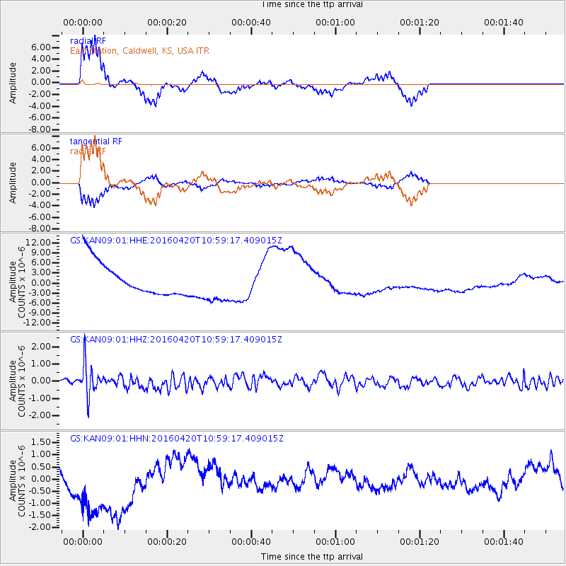
Signal To Noise
| Channel | StoN | STA | LTA |
| GS:KAN09:01:HHZ:20160420T10:59:17.409015Z | 4.916036 | 9.1096484E-7 | 1.8530476E-7 |
| GS:KAN09:01:HHN:20160420T10:59:17.409015Z | 4.501381 | 1.8400299E-6 | 4.087701E-7 |
| GS:KAN09:01:HHE:20160420T10:59:17.409015Z | 1.2076718 | 5.990423E-6 | 4.9603073E-6 |
| Arrivals |
| Ps | 4.1 SECOND |
| PpPs | 13 SECOND |
| PsPs/PpSs | 18 SECOND |


