You are here: Home > Network List > TA - USArray Transportable Network (new EarthScope stations) Stations List
> Station F21K Alatna River, AK, USA > Earthquake Result Viewer
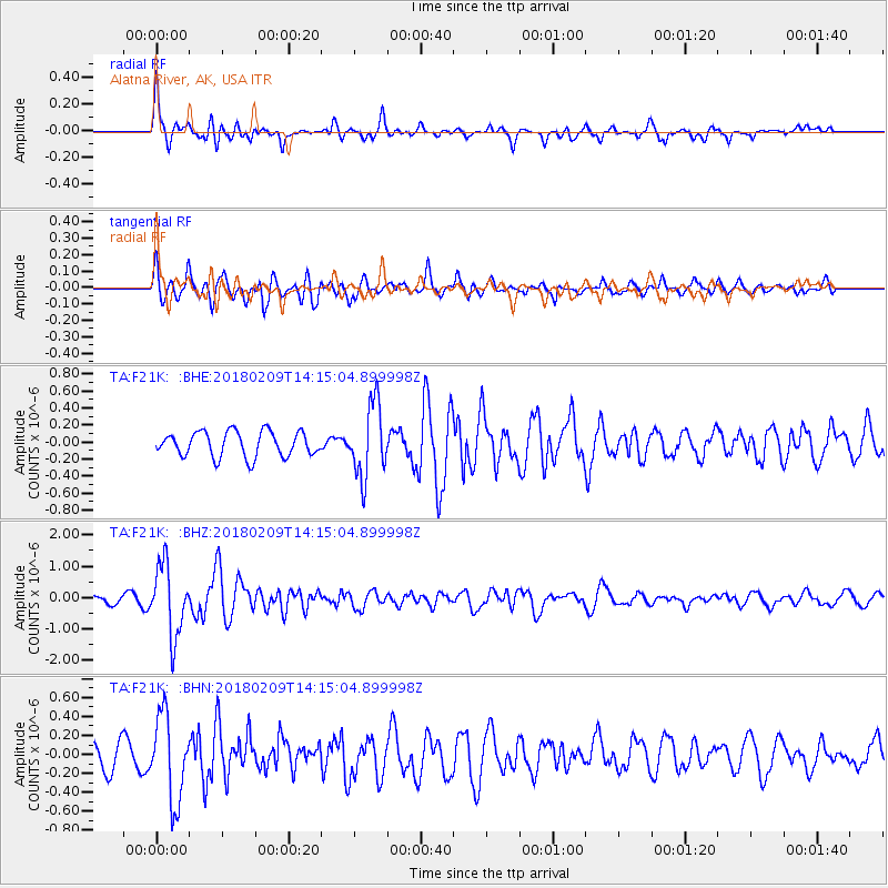
F21K Alatna River, AK, USA - Earthquake Result Viewer
*The percent match for this event was below the threshold and hence no stack was calculated.
| Earthquake location: |
Near Coast Of Jalisco, Mexico |
| Earthquake latitude/longitude: |
18.9/-104.8 |
| Earthquake time(UTC): |
2018/02/09 (040) 14:05:47 GMT |
| Earthquake Depth: |
10 km |
| Earthquake Magnitude: |
5.8 Mww |
| Earthquake Catalog/Contributor: |
NEIC PDE/us |
|
| Network: |
TA USArray Transportable Network (new EarthScope stations) |
| Station: |
F21K Alatna River, AK, USA |
| Lat/Lon: |
67.22 N/153.48 W |
| Elevation: |
597 m |
|
| Distance: |
57.3 deg |
| Az: |
339.665 deg |
| Baz: |
122.327 deg |
| Ray Param: |
$rayparam |
*The percent match for this event was below the threshold and hence was not used in the summary stack. |
|
| Radial Match: |
74.41409 % |
| Radial Bump: |
400 |
| Transverse Match: |
77.3204 % |
| Transverse Bump: |
400 |
| SOD ConfigId: |
13570011 |
| Insert Time: |
2019-04-29 18:49:47.801 +0000 |
| GWidth: |
2.5 |
| Max Bumps: |
400 |
| Tol: |
0.001 |
|
Signal To Noise
| Channel | StoN | STA | LTA |
| TA:F21K: :BHZ:20180209T14:15:04.899998Z | 11.133211 | 1.1301809E-6 | 1.0151436E-7 |
| TA:F21K: :BHN:20180209T14:15:04.899998Z | 4.009347 | 4.5059224E-7 | 1.1238545E-7 |
| TA:F21K: :BHE:20180209T14:15:04.899998Z | 2.9129934 | 4.2672875E-7 | 1.464915E-7 |
| Arrivals |
| Ps | |
| PpPs | |
| PsPs/PpSs | |


