You are here: Home > Network List > TA - USArray Transportable Network (new EarthScope stations) Stations List
> Station F26K Sheenjek River, AK, USA > Earthquake Result Viewer
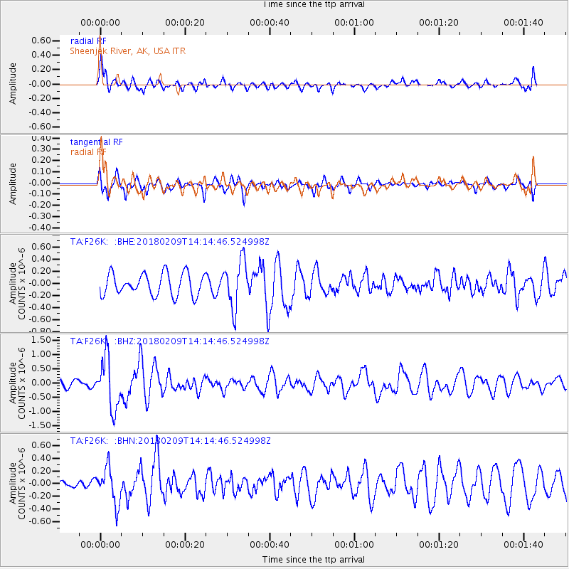
F26K Sheenjek River, AK, USA - Earthquake Result Viewer
*The percent match for this event was below the threshold and hence no stack was calculated.
| Earthquake location: |
Near Coast Of Jalisco, Mexico |
| Earthquake latitude/longitude: |
18.9/-104.8 |
| Earthquake time(UTC): |
2018/02/09 (040) 14:05:47 GMT |
| Earthquake Depth: |
10 km |
| Earthquake Magnitude: |
5.8 Mww |
| Earthquake Catalog/Contributor: |
NEIC PDE/us |
|
| Network: |
TA USArray Transportable Network (new EarthScope stations) |
| Station: |
F26K Sheenjek River, AK, USA |
| Lat/Lon: |
67.69 N/144.15 W |
| Elevation: |
683 m |
|
| Distance: |
54.8 deg |
| Az: |
342.757 deg |
| Baz: |
132.673 deg |
| Ray Param: |
$rayparam |
*The percent match for this event was below the threshold and hence was not used in the summary stack. |
|
| Radial Match: |
69.52073 % |
| Radial Bump: |
400 |
| Transverse Match: |
58.93182 % |
| Transverse Bump: |
400 |
| SOD ConfigId: |
13570011 |
| Insert Time: |
2019-04-29 18:49:49.648 +0000 |
| GWidth: |
2.5 |
| Max Bumps: |
400 |
| Tol: |
0.001 |
|
Signal To Noise
| Channel | StoN | STA | LTA |
| TA:F26K: :BHZ:20180209T14:14:46.524998Z | 6.694928 | 8.985413E-7 | 1.3421224E-7 |
| TA:F26K: :BHN:20180209T14:14:46.524998Z | 2.5518322 | 2.8792388E-7 | 1.1283026E-7 |
| TA:F26K: :BHE:20180209T14:14:46.524998Z | 2.177965 | 3.9775236E-7 | 1.8262568E-7 |
| Arrivals |
| Ps | |
| PpPs | |
| PsPs/PpSs | |


