You are here: Home > Network List > TA - USArray Transportable Network (new EarthScope stations) Stations List
> Station X14A Yava, AZ, USA > Earthquake Result Viewer
X14A Yava, AZ, USA - Earthquake Result Viewer
| Earthquake location: |
Loyalty Islands |
| Earthquake latitude/longitude: |
-20.3/168.8 |
| Earthquake time(UTC): |
2008/04/19 (110) 05:58:42 GMT |
| Earthquake Depth: |
14 km |
| Earthquake Magnitude: |
5.7 MB, 6.2 MS, 6.3 MW, 6.2 MW |
| Earthquake Catalog/Contributor: |
WHDF/NEIC |
|
| Network: |
TA USArray Transportable Network (new EarthScope stations) |
| Station: |
X14A Yava, AZ, USA |
| Lat/Lon: |
34.47 N/112.89 W |
| Elevation: |
1078 m |
|
| Distance: |
92.1 deg |
| Az: |
54.059 deg |
| Baz: |
246.922 deg |
| Ray Param: |
0.041505434 |
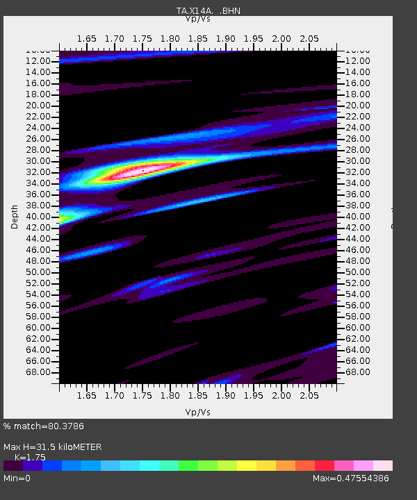
| Estimated Moho Depth: |
31.5 km |
| Estimated Crust Vp/Vs: |
1.75 |
| Assumed Crust Vp: |
6.276 km/s |
| Estimated Crust Vs: |
3.586 km/s |
| Estimated Crust Poisson's Ratio: |
0.26 |
|
| Radial Match: |
80.3786 % |
| Radial Bump: |
355 |
| Transverse Match: |
55.443005 % |
| Transverse Bump: |
400 |
| SOD ConfigId: |
2504 |
| Insert Time: |
2010-03-06 08:54:16.755 +0000 |
| GWidth: |
2.5 |
| Max Bumps: |
400 |
| Tol: |
0.001 |
|

Signal To Noise
| Channel | StoN | STA | LTA |
| TA:X14A: :BHN:20080419T06:11:19.400024Z | 2.8634923 | 3.7609598E-7 | 1.3134172E-7 |
| TA:X14A: :BHE:20080419T06:11:19.400024Z | 1.2454944 | 7.5952684E-8 | 6.0981954E-8 |
| TA:X14A: :BHZ:20080419T06:11:19.400024Z | 1.1257286 | 1.506273E-7 | 1.3380428E-7 |
| Arrivals |
| Ps | 3.8 SECOND |
| PpPs | 14 SECOND |
| PsPs/PpSs | 17 SECOND |


