You are here: Home > Network List > TA - USArray Transportable Network (new EarthScope stations) Stations List
> Station R33M Jennings River, BC, CAN > Earthquake Result Viewer
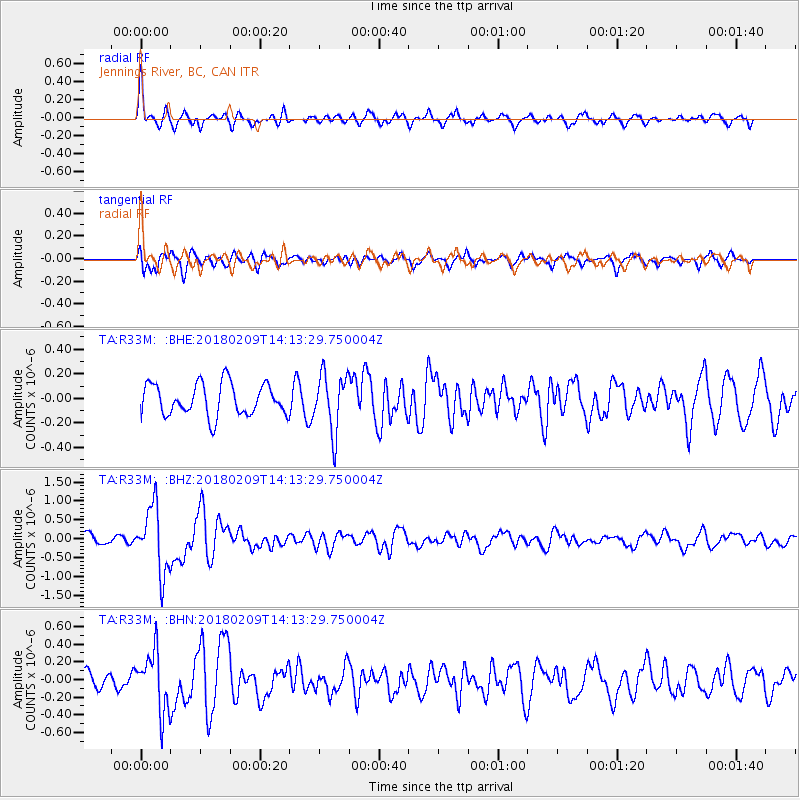
R33M Jennings River, BC, CAN - Earthquake Result Viewer
*The percent match for this event was below the threshold and hence no stack was calculated.
| Earthquake location: |
Near Coast Of Jalisco, Mexico |
| Earthquake latitude/longitude: |
18.9/-104.8 |
| Earthquake time(UTC): |
2018/02/09 (040) 14:05:47 GMT |
| Earthquake Depth: |
10 km |
| Earthquake Magnitude: |
5.8 Mww |
| Earthquake Catalog/Contributor: |
NEIC PDE/us |
|
| Network: |
TA USArray Transportable Network (new EarthScope stations) |
| Station: |
R33M Jennings River, BC, CAN |
| Lat/Lon: |
59.39 N/130.97 W |
| Elevation: |
1437 m |
|
| Distance: |
44.7 deg |
| Az: |
341.262 deg |
| Baz: |
143.526 deg |
| Ray Param: |
$rayparam |
*The percent match for this event was below the threshold and hence was not used in the summary stack. |
|
| Radial Match: |
78.22498 % |
| Radial Bump: |
384 |
| Transverse Match: |
61.837936 % |
| Transverse Bump: |
400 |
| SOD ConfigId: |
13570011 |
| Insert Time: |
2019-04-29 18:51:04.543 +0000 |
| GWidth: |
2.5 |
| Max Bumps: |
400 |
| Tol: |
0.001 |
|
Signal To Noise
| Channel | StoN | STA | LTA |
| TA:R33M: :BHZ:20180209T14:13:29.750004Z | 6.906245 | 8.72537E-7 | 1.2634028E-7 |
| TA:R33M: :BHN:20180209T14:13:29.750004Z | 2.917574 | 3.3747173E-7 | 1.1566862E-7 |
| TA:R33M: :BHE:20180209T14:13:29.750004Z | 1.8302771 | 2.3646746E-7 | 1.2919763E-7 |
| Arrivals |
| Ps | |
| PpPs | |
| PsPs/PpSs | |


