You are here: Home > Network List > GS - US Geological Survey Networks Stations List
> Station OK031 2598 S. Brethren Rd., Cushing, OK, USA > Earthquake Result Viewer
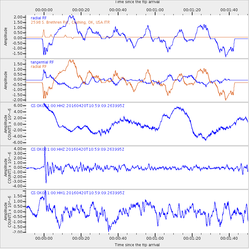
OK031 2598 S. Brethren Rd., Cushing, OK, USA - Earthquake Result Viewer
*The percent match for this event was below the threshold and hence no stack was calculated.
| Earthquake location: |
North Atlantic Ocean |
| Earthquake latitude/longitude: |
13.2/-55.9 |
| Earthquake time(UTC): |
2016/04/20 (111) 10:51:39 GMT |
| Earthquake Depth: |
10 km |
| Earthquake Magnitude: |
5.8 MB |
| Earthquake Catalog/Contributor: |
NEIC PDE/NEIC COMCAT |
|
| Network: |
GS US Geological Survey Networks |
| Station: |
OK031 2598 S. Brethren Rd., Cushing, OK, USA |
| Lat/Lon: |
35.95 N/96.84 W |
| Elevation: |
290 m |
|
| Distance: |
43.1 deg |
| Az: |
308.989 deg |
| Baz: |
111.096 deg |
| Ray Param: |
$rayparam |
*The percent match for this event was below the threshold and hence was not used in the summary stack. |
|
| Radial Match: |
24.16122 % |
| Radial Bump: |
400 |
| Transverse Match: |
37.537067 % |
| Transverse Bump: |
400 |
| SOD ConfigId: |
1475611 |
| Insert Time: |
2016-05-04 10:56:19.061 +0000 |
| GWidth: |
2.5 |
| Max Bumps: |
400 |
| Tol: |
0.001 |
|
Signal To Noise
| Channel | StoN | STA | LTA |
| GS:OK031:00:HHZ:20160420T10:59:09.263995Z | 10.788869 | 1.4876297E-6 | 1.378856E-7 |
| GS:OK031:00:HH1:20160420T10:59:09.263995Z | 1.6652704 | 1.4710362E-6 | 8.8336174E-7 |
| GS:OK031:00:HH2:20160420T10:59:09.263995Z | 1.0902871 | 2.8806942E-6 | 2.6421426E-6 |
| Arrivals |
| Ps | |
| PpPs | |
| PsPs/PpSs | |


