You are here: Home > Network List > UW - Pacific Northwest Regional Seismic Network Stations List
> Station LEBA Lebam, WA, USA > Earthquake Result Viewer
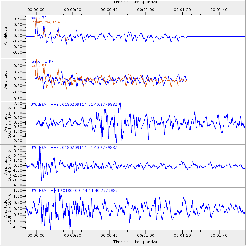
LEBA Lebam, WA, USA - Earthquake Result Viewer
*The percent match for this event was below the threshold and hence no stack was calculated.
| Earthquake location: |
Near Coast Of Jalisco, Mexico |
| Earthquake latitude/longitude: |
18.9/-104.8 |
| Earthquake time(UTC): |
2018/02/09 (040) 14:05:47 GMT |
| Earthquake Depth: |
10 km |
| Earthquake Magnitude: |
5.8 Mww |
| Earthquake Catalog/Contributor: |
NEIC PDE/us |
|
| Network: |
UW Pacific Northwest Regional Seismic Network |
| Station: |
LEBA Lebam, WA, USA |
| Lat/Lon: |
46.55 N/123.56 W |
| Elevation: |
73 m |
|
| Distance: |
31.6 deg |
| Az: |
334.915 deg |
| Baz: |
144.437 deg |
| Ray Param: |
$rayparam |
*The percent match for this event was below the threshold and hence was not used in the summary stack. |
|
| Radial Match: |
77.195854 % |
| Radial Bump: |
367 |
| Transverse Match: |
62.774544 % |
| Transverse Bump: |
400 |
| SOD ConfigId: |
13570011 |
| Insert Time: |
2019-04-29 18:51:39.588 +0000 |
| GWidth: |
2.5 |
| Max Bumps: |
400 |
| Tol: |
0.001 |
|
Signal To Noise
| Channel | StoN | STA | LTA |
| UW:LEBA: :HHZ:20180209T14:11:40.277988Z | 6.748192 | 1.5583003E-6 | 2.3092116E-7 |
| UW:LEBA: :HHN:20180209T14:11:40.277988Z | 3.105695 | 7.0380736E-7 | 2.2661831E-7 |
| UW:LEBA: :HHE:20180209T14:11:40.277988Z | 2.6774044 | 6.384918E-7 | 2.384742E-7 |
| Arrivals |
| Ps | |
| PpPs | |
| PsPs/PpSs | |


