You are here: Home > Network List > CI - Caltech Regional Seismic Network Stations List
> Station MPP McPhearson Peak > Earthquake Result Viewer
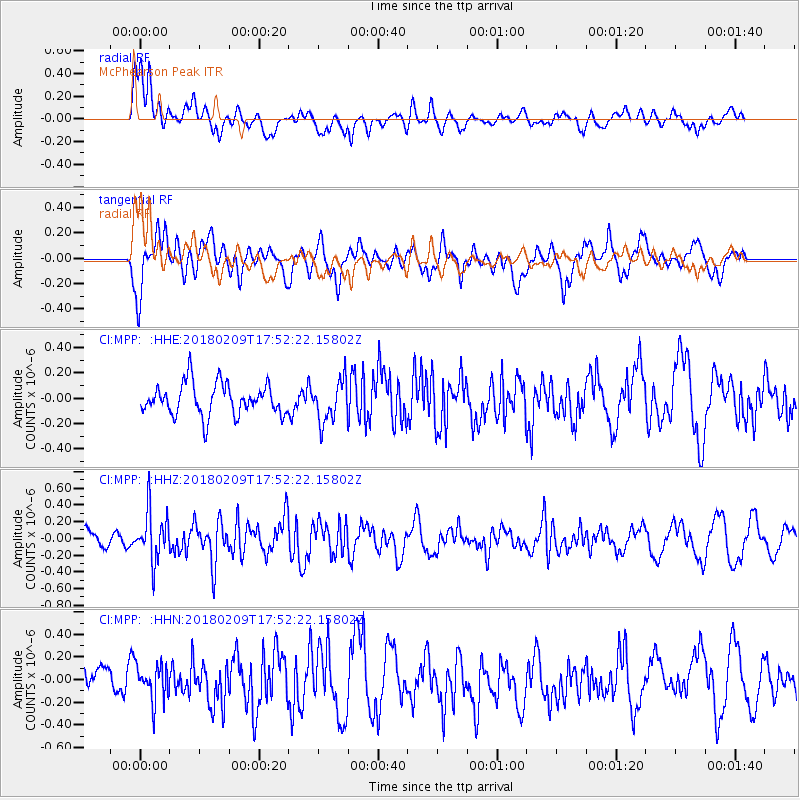
MPP McPhearson Peak - Earthquake Result Viewer
*The percent match for this event was below the threshold and hence no stack was calculated.
| Earthquake location: |
Leeward Islands |
| Earthquake latitude/longitude: |
19.0/-61.7 |
| Earthquake time(UTC): |
2018/02/09 (040) 17:43:34 GMT |
| Earthquake Depth: |
9.9 km |
| Earthquake Magnitude: |
5.5 Mi |
| Earthquake Catalog/Contributor: |
NEIC PDE/pt |
|
| Network: |
CI Caltech Regional Seismic Network |
| Station: |
MPP McPhearson Peak |
| Lat/Lon: |
34.89 N/119.81 W |
| Elevation: |
1739 m |
|
| Distance: |
53.5 deg |
| Az: |
299.731 deg |
| Baz: |
91.39 deg |
| Ray Param: |
$rayparam |
*The percent match for this event was below the threshold and hence was not used in the summary stack. |
|
| Radial Match: |
54.398552 % |
| Radial Bump: |
400 |
| Transverse Match: |
55.41822 % |
| Transverse Bump: |
400 |
| SOD ConfigId: |
13570011 |
| Insert Time: |
2019-04-29 18:54:30.516 +0000 |
| GWidth: |
2.5 |
| Max Bumps: |
400 |
| Tol: |
0.001 |
|
Signal To Noise
| Channel | StoN | STA | LTA |
| CI:MPP: :HHZ:20180209T17:52:22.15802Z | 1.9676981 | 2.9507098E-7 | 1.4995746E-7 |
| CI:MPP: :HHN:20180209T17:52:22.15802Z | 1.0105642 | 1.5776466E-7 | 1.5611542E-7 |
| CI:MPP: :HHE:20180209T17:52:22.15802Z | 1.4593841 | 1.8494904E-7 | 1.267309E-7 |
| Arrivals |
| Ps | |
| PpPs | |
| PsPs/PpSs | |


