You are here: Home > Network List > CN - Canadian National Seismograph Network Stations List
> Station INK INUVIK, NT > Earthquake Result Viewer
INK INUVIK, NT - Earthquake Result Viewer
*The percent match for this event was below the threshold and hence no stack was calculated.
| Earthquake location: |
Leeward Islands |
| Earthquake latitude/longitude: |
19.0/-61.7 |
| Earthquake time(UTC): |
2018/02/09 (040) 17:43:34 GMT |
| Earthquake Depth: |
9.9 km |
| Earthquake Magnitude: |
5.5 Mi |
| Earthquake Catalog/Contributor: |
NEIC PDE/pt |
|
| Network: |
CN Canadian National Seismograph Network |
| Station: |
INK INUVIK, NT |
| Lat/Lon: |
68.31 N/133.53 W |
| Elevation: |
44 m |
|
| Distance: |
65.8 deg |
| Az: |
337.222 deg |
| Baz: |
99.758 deg |
| Ray Param: |
$rayparam |
*The percent match for this event was below the threshold and hence was not used in the summary stack. |
|
| Radial Match: |
18.207785 % |
| Radial Bump: |
400 |
| Transverse Match: |
35.19781 % |
| Transverse Bump: |
400 |
| SOD ConfigId: |
13570011 |
| Insert Time: |
2019-04-29 18:54:52.069 +0000 |
| GWidth: |
2.5 |
| Max Bumps: |
400 |
| Tol: |
0.001 |
|
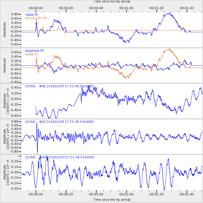
Signal To Noise
| Channel | StoN | STA | LTA |
| CN:INK: :BHZ:20180209T17:53:48.549988Z | 2.5275028 | 2.875778E-7 | 1.1377941E-7 |
| CN:INK: :BHN:20180209T17:53:48.549988Z | 1.5202713 | 1.8712247E-7 | 1.2308492E-7 |
| CN:INK: :BHE:20180209T17:53:48.549988Z | 4.7166524 | 6.426635E-7 | 1.3625416E-7 |
| Arrivals |
| Ps | |
| PpPs | |
| PsPs/PpSs | |


