You are here: Home > Network List > TA - USArray Transportable Network (new EarthScope stations) Stations List
> Station BGNE Belgrade, NE, USA > Earthquake Result Viewer
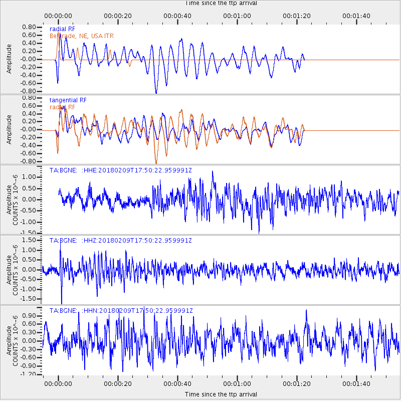
BGNE Belgrade, NE, USA - Earthquake Result Viewer
*The percent match for this event was below the threshold and hence no stack was calculated.
| Earthquake location: |
Leeward Islands |
| Earthquake latitude/longitude: |
19.0/-61.7 |
| Earthquake time(UTC): |
2018/02/09 (040) 17:43:34 GMT |
| Earthquake Depth: |
9.9 km |
| Earthquake Magnitude: |
5.5 Mi |
| Earthquake Catalog/Contributor: |
NEIC PDE/pt |
|
| Network: |
TA USArray Transportable Network (new EarthScope stations) |
| Station: |
BGNE Belgrade, NE, USA |
| Lat/Lon: |
41.41 N/98.15 W |
| Elevation: |
573 m |
|
| Distance: |
38.2 deg |
| Az: |
313.796 deg |
| Baz: |
114.75 deg |
| Ray Param: |
$rayparam |
*The percent match for this event was below the threshold and hence was not used in the summary stack. |
|
| Radial Match: |
61.200333 % |
| Radial Bump: |
400 |
| Transverse Match: |
52.118168 % |
| Transverse Bump: |
400 |
| SOD ConfigId: |
13570011 |
| Insert Time: |
2019-04-29 18:57:27.538 +0000 |
| GWidth: |
2.5 |
| Max Bumps: |
400 |
| Tol: |
0.001 |
|
Signal To Noise
| Channel | StoN | STA | LTA |
| TA:BGNE: :HHZ:20180209T17:50:22.959991Z | 2.3607044 | 5.0458146E-7 | 2.1374191E-7 |
| TA:BGNE: :HHN:20180209T17:50:22.959991Z | 0.8656498 | 2.5544898E-7 | 2.9509505E-7 |
| TA:BGNE: :HHE:20180209T17:50:22.959991Z | 1.4514266 | 3.598621E-7 | 2.479368E-7 |
| Arrivals |
| Ps | |
| PpPs | |
| PsPs/PpSs | |


