You are here: Home > Network List > IW - Intermountain West Stations List
> Station DLMT Dillon, Montana, USA > Earthquake Result Viewer
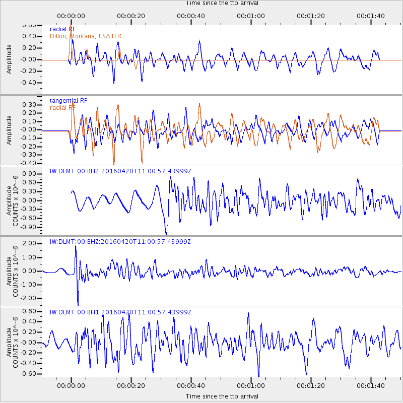
DLMT Dillon, Montana, USA - Earthquake Result Viewer
*The percent match for this event was below the threshold and hence no stack was calculated.
| Earthquake location: |
North Atlantic Ocean |
| Earthquake latitude/longitude: |
13.2/-55.9 |
| Earthquake time(UTC): |
2016/04/20 (111) 10:51:39 GMT |
| Earthquake Depth: |
10 km |
| Earthquake Magnitude: |
5.8 MB |
| Earthquake Catalog/Contributor: |
NEIC PDE/NEIC COMCAT |
|
| Network: |
IW Intermountain West |
| Station: |
DLMT Dillon, Montana, USA |
| Lat/Lon: |
45.36 N/112.60 W |
| Elevation: |
1569 m |
|
| Distance: |
57.4 deg |
| Az: |
315.66 deg |
| Baz: |
105.096 deg |
| Ray Param: |
$rayparam |
*The percent match for this event was below the threshold and hence was not used in the summary stack. |
|
| Radial Match: |
57.210323 % |
| Radial Bump: |
400 |
| Transverse Match: |
62.617302 % |
| Transverse Bump: |
400 |
| SOD ConfigId: |
1475611 |
| Insert Time: |
2016-05-04 10:59:51.601 +0000 |
| GWidth: |
2.5 |
| Max Bumps: |
400 |
| Tol: |
0.001 |
|
Signal To Noise
| Channel | StoN | STA | LTA |
| IW:DLMT:00:BHZ:20160420T11:00:57.43999Z | 4.0237584 | 8.450992E-7 | 2.1002731E-7 |
| IW:DLMT:00:BH1:20160420T11:00:57.43999Z | 1.524778 | 1.6922603E-7 | 1.1098404E-7 |
| IW:DLMT:00:BH2:20160420T11:00:57.43999Z | 2.886977 | 5.715978E-7 | 1.9799181E-7 |
| Arrivals |
| Ps | |
| PpPs | |
| PsPs/PpSs | |


