You are here: Home > Network List > IW - Intermountain West Stations List
> Station MOOW Moose Ponds, Wyoming, USA > Earthquake Result Viewer
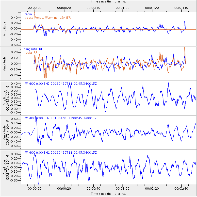
MOOW Moose Ponds, Wyoming, USA - Earthquake Result Viewer
*The percent match for this event was below the threshold and hence no stack was calculated.
| Earthquake location: |
North Atlantic Ocean |
| Earthquake latitude/longitude: |
13.2/-55.9 |
| Earthquake time(UTC): |
2016/04/20 (111) 10:51:39 GMT |
| Earthquake Depth: |
10 km |
| Earthquake Magnitude: |
5.8 MB |
| Earthquake Catalog/Contributor: |
NEIC PDE/NEIC COMCAT |
|
| Network: |
IW Intermountain West |
| Station: |
MOOW Moose Ponds, Wyoming, USA |
| Lat/Lon: |
43.75 N/110.74 W |
| Elevation: |
2128 m |
|
| Distance: |
55.7 deg |
| Az: |
314.216 deg |
| Baz: |
105.596 deg |
| Ray Param: |
$rayparam |
*The percent match for this event was below the threshold and hence was not used in the summary stack. |
|
| Radial Match: |
48.716618 % |
| Radial Bump: |
400 |
| Transverse Match: |
57.582497 % |
| Transverse Bump: |
400 |
| SOD ConfigId: |
1475611 |
| Insert Time: |
2016-05-04 11:00:53.394 +0000 |
| GWidth: |
2.5 |
| Max Bumps: |
400 |
| Tol: |
0.001 |
|
Signal To Noise
| Channel | StoN | STA | LTA |
| IW:MOOW:00:BHZ:20160420T11:00:45.340015Z | 4.323858 | 3.8572463E-7 | 8.920844E-8 |
| IW:MOOW:00:BH1:20160420T11:00:45.340015Z | 2.1838524 | 2.2332921E-7 | 1.02263876E-7 |
| IW:MOOW:00:BH2:20160420T11:00:45.340015Z | 0.6746961 | 1.1786594E-7 | 1.7469485E-7 |
| Arrivals |
| Ps | |
| PpPs | |
| PsPs/PpSs | |


