You are here: Home > Network List > IW - Intermountain West Stations List
> Station PLID Pearl Lake, Idaho, USA > Earthquake Result Viewer
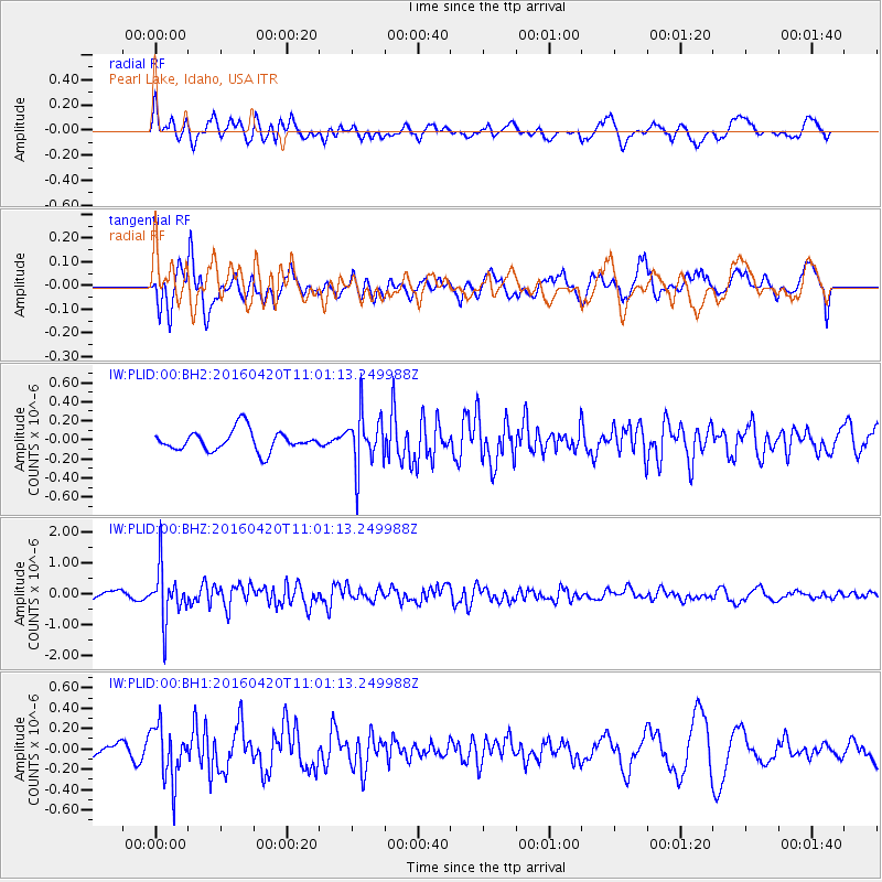
PLID Pearl Lake, Idaho, USA - Earthquake Result Viewer
*The percent match for this event was below the threshold and hence no stack was calculated.
| Earthquake location: |
North Atlantic Ocean |
| Earthquake latitude/longitude: |
13.2/-55.9 |
| Earthquake time(UTC): |
2016/04/20 (111) 10:51:39 GMT |
| Earthquake Depth: |
10 km |
| Earthquake Magnitude: |
5.8 MB |
| Earthquake Catalog/Contributor: |
NEIC PDE/NEIC COMCAT |
|
| Network: |
IW Intermountain West |
| Station: |
PLID Pearl Lake, Idaho, USA |
| Lat/Lon: |
45.09 N/116.00 W |
| Elevation: |
2164 m |
|
| Distance: |
59.7 deg |
| Az: |
314.682 deg |
| Baz: |
102.178 deg |
| Ray Param: |
$rayparam |
*The percent match for this event was below the threshold and hence was not used in the summary stack. |
|
| Radial Match: |
69.978386 % |
| Radial Bump: |
400 |
| Transverse Match: |
51.18862 % |
| Transverse Bump: |
400 |
| SOD ConfigId: |
1475611 |
| Insert Time: |
2016-05-04 11:01:00.283 +0000 |
| GWidth: |
2.5 |
| Max Bumps: |
400 |
| Tol: |
0.001 |
|
Signal To Noise
| Channel | StoN | STA | LTA |
| IW:PLID:00:BHZ:20160420T11:01:13.249988Z | 5.2634473 | 8.301055E-7 | 1.5771138E-7 |
| IW:PLID:00:BH1:20160420T11:01:13.249988Z | 2.9659183 | 2.6609044E-7 | 8.971604E-8 |
| IW:PLID:00:BH2:20160420T11:01:13.249988Z | 2.5464652 | 2.7507036E-7 | 1.0802047E-7 |
| Arrivals |
| Ps | |
| PpPs | |
| PsPs/PpSs | |


