You are here: Home > Network List > TA - USArray Transportable Network (new EarthScope stations) Stations List
> Station G06A Carlson Farm, Grass Valley, OR, USA > Earthquake Result Viewer
G06A Carlson Farm, Grass Valley, OR, USA - Earthquake Result Viewer
| Earthquake location: |
South Of Fiji Islands |
| Earthquake latitude/longitude: |
-26.0/-177.5 |
| Earthquake time(UTC): |
2007/12/09 (343) 07:28:20 GMT |
| Earthquake Depth: |
152 km |
| Earthquake Magnitude: |
7.0 MB, 7.8 MW, 7.7 MW |
| Earthquake Catalog/Contributor: |
WHDF/NEIC |
|
| Network: |
TA USArray Transportable Network (new EarthScope stations) |
| Station: |
G06A Carlson Farm, Grass Valley, OR, USA |
| Lat/Lon: |
45.24 N/120.64 W |
| Elevation: |
780 m |
|
| Distance: |
87.8 deg |
| Az: |
36.314 deg |
| Baz: |
228.966 deg |
| Ray Param: |
0.042742055 |
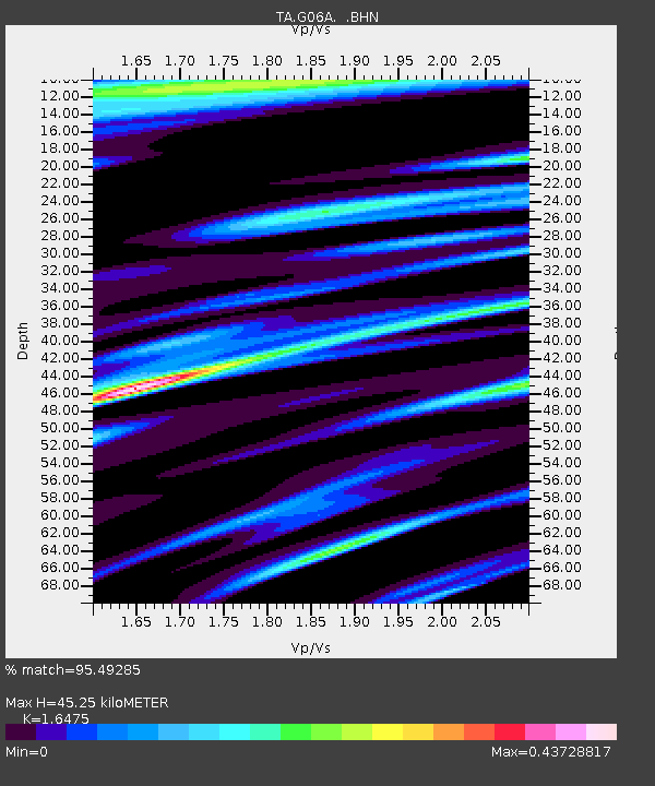
| Estimated Moho Depth: |
45.25 km |
| Estimated Crust Vp/Vs: |
1.65 |
| Assumed Crust Vp: |
6.597 km/s |
| Estimated Crust Vs: |
4.005 km/s |
| Estimated Crust Poisson's Ratio: |
0.21 |
|
| Radial Match: |
95.49285 % |
| Radial Bump: |
400 |
| Transverse Match: |
90.314476 % |
| Transverse Bump: |
293 |
| SOD ConfigId: |
2564 |
| Insert Time: |
2010-03-06 08:56:25.411 +0000 |
| GWidth: |
2.5 |
| Max Bumps: |
400 |
| Tol: |
0.001 |
|

Signal To Noise
| Channel | StoN | STA | LTA |
| TA:G06A: :BHN:20071209T07:40:21.325005Z | 1.2503586 | 2.7002307E-7 | 2.1595649E-7 |
| TA:G06A: :BHE:20071209T07:40:21.325005Z | 1.6478364 | 3.757773E-7 | 2.2804284E-7 |
| TA:G06A: :BHZ:20071209T07:40:21.325005Z | 8.674752 | 1.7732173E-6 | 2.0441126E-7 |
| Arrivals |
| Ps | 4.6 SECOND |
| PpPs | 18 SECOND |
| PsPs/PpSs | 22 SECOND |


