You are here: Home > Network List > TA - USArray Transportable Network (new EarthScope stations) Stations List
> Station G06A Carlson Farm, Grass Valley, OR, USA > Earthquake Result Viewer
G06A Carlson Farm, Grass Valley, OR, USA - Earthquake Result Viewer
| Earthquake location: |
Mariana Islands |
| Earthquake latitude/longitude: |
18.9/145.4 |
| Earthquake time(UTC): |
2007/10/31 (304) 03:30:17 GMT |
| Earthquake Depth: |
223 km |
| Earthquake Magnitude: |
6.2 MB, 7.2 MW, 7.2 MW |
| Earthquake Catalog/Contributor: |
WHDF/NEIC |
|
| Network: |
TA USArray Transportable Network (new EarthScope stations) |
| Station: |
G06A Carlson Farm, Grass Valley, OR, USA |
| Lat/Lon: |
45.24 N/120.64 W |
| Elevation: |
780 m |
|
| Distance: |
79.6 deg |
| Az: |
45.783 deg |
| Baz: |
286.19 deg |
| Ray Param: |
0.048307132 |
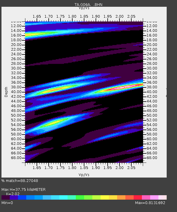
| Estimated Moho Depth: |
37.75 km |
| Estimated Crust Vp/Vs: |
2.02 |
| Assumed Crust Vp: |
6.597 km/s |
| Estimated Crust Vs: |
3.266 km/s |
| Estimated Crust Poisson's Ratio: |
0.34 |
|
| Radial Match: |
88.27048 % |
| Radial Bump: |
400 |
| Transverse Match: |
79.78839 % |
| Transverse Bump: |
400 |
| SOD ConfigId: |
2564 |
| Insert Time: |
2010-03-06 08:56:36.826 +0000 |
| GWidth: |
2.5 |
| Max Bumps: |
400 |
| Tol: |
0.001 |
|

Signal To Noise
| Channel | StoN | STA | LTA |
| TA:G06A: :BHN:20071031T03:41:28.574001Z | 2.7653325 | 4.7654368E-7 | 1.723278E-7 |
| TA:G06A: :BHE:20071031T03:41:28.574001Z | 8.607969 | 1.7507654E-6 | 2.033889E-7 |
| TA:G06A: :BHZ:20071031T03:41:28.574001Z | 18.76327 | 4.0977225E-6 | 2.1839065E-7 |
| Arrivals |
| Ps | 6.0 SECOND |
| PpPs | 17 SECOND |
| PsPs/PpSs | 23 SECOND |


