You are here: Home > Network List > TA - USArray Transportable Network (new EarthScope stations) Stations List
> Station G06A Carlson Farm, Grass Valley, OR, USA > Earthquake Result Viewer
G06A Carlson Farm, Grass Valley, OR, USA - Earthquake Result Viewer
| Earthquake location: |
Andreanof Islands, Aleutian Is. |
| Earthquake latitude/longitude: |
51.3/-180.0 |
| Earthquake time(UTC): |
2007/08/02 (214) 03:21:42 GMT |
| Earthquake Depth: |
21 km |
| Earthquake Magnitude: |
6.3 MB, 6.6 MS, 6.7 MW, 6.6 MW |
| Earthquake Catalog/Contributor: |
WHDF/NEIC |
|
| Network: |
TA USArray Transportable Network (new EarthScope stations) |
| Station: |
G06A Carlson Farm, Grass Valley, OR, USA |
| Lat/Lon: |
45.24 N/120.64 W |
| Elevation: |
780 m |
|
| Distance: |
39.0 deg |
| Az: |
74.928 deg |
| Baz: |
300.927 deg |
| Ray Param: |
0.07520452 |
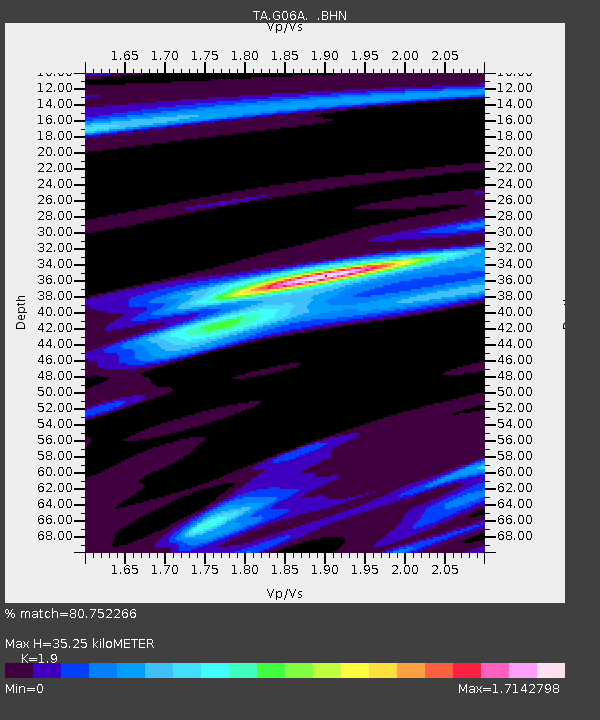
| Estimated Moho Depth: |
35.25 km |
| Estimated Crust Vp/Vs: |
1.90 |
| Assumed Crust Vp: |
6.597 km/s |
| Estimated Crust Vs: |
3.472 km/s |
| Estimated Crust Poisson's Ratio: |
0.31 |
|
| Radial Match: |
80.752266 % |
| Radial Bump: |
396 |
| Transverse Match: |
79.10496 % |
| Transverse Bump: |
400 |
| SOD ConfigId: |
2564 |
| Insert Time: |
2010-03-06 08:56:49.930 +0000 |
| GWidth: |
2.5 |
| Max Bumps: |
400 |
| Tol: |
0.001 |
|
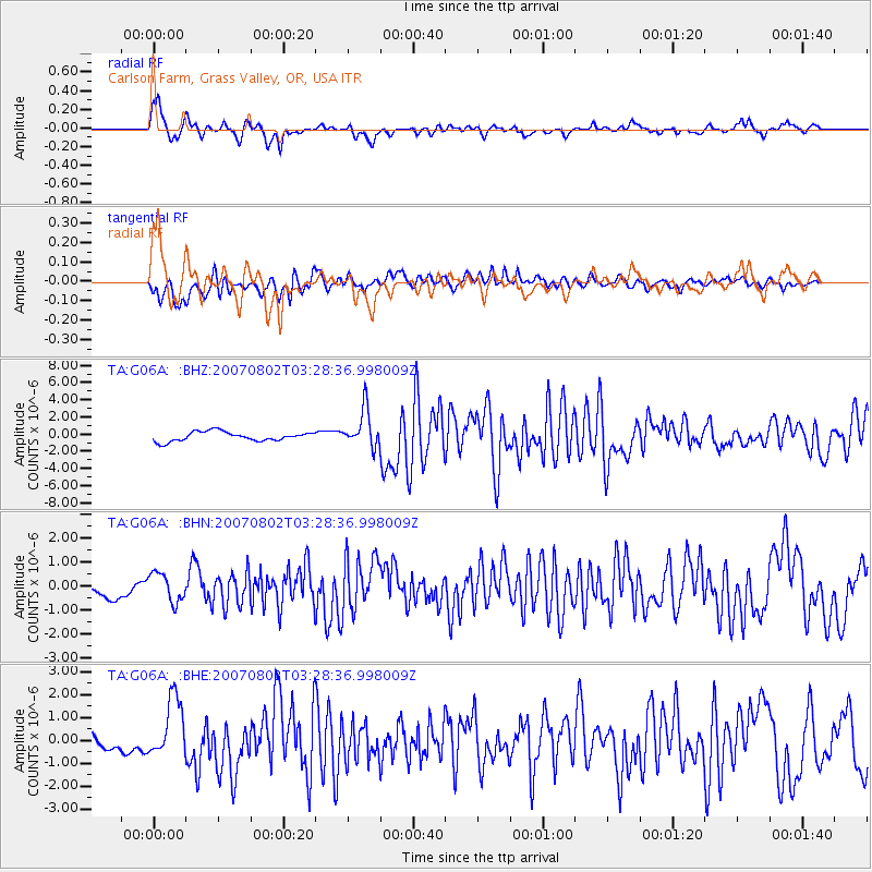
Signal To Noise
| Channel | StoN | STA | LTA |
| TA:G06A: :BHN:20070802T03:28:36.998009Z | 2.1744242 | 6.070446E-7 | 2.791749E-7 |
| TA:G06A: :BHE:20070802T03:28:36.998009Z | 3.686038 | 1.2929522E-6 | 3.5077016E-7 |
| TA:G06A: :BHZ:20070802T03:28:36.998009Z | 4.0084267 | 2.1949559E-6 | 5.475854E-7 |
| Arrivals |
| Ps | 5.2 SECOND |
| PpPs | 14 SECOND |
| PsPs/PpSs | 20 SECOND |


