You are here: Home > Network List > TA - USArray Transportable Network (new EarthScope stations) Stations List
> Station G06A Carlson Farm, Grass Valley, OR, USA > Earthquake Result Viewer
G06A Carlson Farm, Grass Valley, OR, USA - Earthquake Result Viewer

| Earthquake location: |
South Of Fiji Islands |
| Earthquake latitude/longitude: |
-26.2/-177.7 |
| Earthquake time(UTC): |
2007/07/17 (198) 09:39:27 GMT |
| Earthquake Depth: |
10 km |
| Earthquake Magnitude: |
5.7 MB, 6.0 MS, 6.1 MW, 6.0 MW |
| Earthquake Catalog/Contributor: |
WHDF/NEIC |
|
| Network: |
TA USArray Transportable Network (new EarthScope stations) |
| Station: |
G06A Carlson Farm, Grass Valley, OR, USA |
| Lat/Lon: |
45.24 N/120.64 W |
| Elevation: |
780 m |
|
| Distance: |
88.1 deg |
| Az: |
36.417 deg |
| Baz: |
229.009 deg |
| Ray Param: |
0.042869702 |
| Estimated Moho Depth: |
58.75 km |
| Estimated Crust Vp/Vs: |
2.04 |
| Assumed Crust Vp: |
6.597 km/s |
| Estimated Crust Vs: |
3.238 km/s |
| Estimated Crust Poisson's Ratio: |
0.34 |
|
| Radial Match: |
83.10905 % |
| Radial Bump: |
400 |
| Transverse Match: |
71.75912 % |
| Transverse Bump: |
400 |
| SOD ConfigId: |
2564 |
| Insert Time: |
2010-03-06 08:56:56.022 +0000 |
| GWidth: |
2.5 |
| Max Bumps: |
400 |
| Tol: |
0.001 |
|
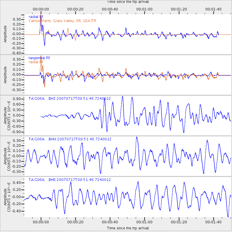
Signal To Noise
| Channel | StoN | STA | LTA |
| TA:G06A: :BHN:20070717T09:51:46.724001Z | 0.736012 | 4.6881937E-8 | 6.369724E-8 |
| TA:G06A: :BHE:20070717T09:51:46.724001Z | 0.7030973 | 3.1927016E-8 | 4.5409106E-8 |
| TA:G06A: :BHZ:20070717T09:51:46.724001Z | 2.2502675 | 1.6101687E-7 | 7.1554545E-8 |
| Arrivals |
| Ps | 9.4 SECOND |
| PpPs | 27 SECOND |
| PsPs/PpSs | 36 SECOND |


