You are here: Home > Network List > CI - Caltech Regional Seismic Network Stations List
> Station SWS Sam W. Stewart, Westmorland, CA, USA > Earthquake Result Viewer
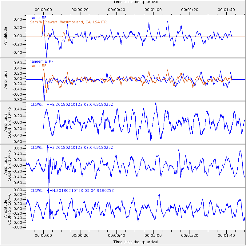
SWS Sam W. Stewart, Westmorland, CA, USA - Earthquake Result Viewer
*The percent match for this event was below the threshold and hence no stack was calculated.
| Earthquake location: |
New Ireland Region, P.N.G. |
| Earthquake latitude/longitude: |
-3.8/151.9 |
| Earthquake time(UTC): |
2018/02/10 (041) 22:50:48 GMT |
| Earthquake Depth: |
268 km |
| Earthquake Magnitude: |
5.8 Mww |
| Earthquake Catalog/Contributor: |
NEIC PDE/us |
|
| Network: |
CI Caltech Regional Seismic Network |
| Station: |
SWS Sam W. Stewart, Westmorland, CA, USA |
| Lat/Lon: |
32.94 N/115.80 W |
| Elevation: |
140 m |
|
| Distance: |
94.0 deg |
| Az: |
57.377 deg |
| Baz: |
268.054 deg |
| Ray Param: |
$rayparam |
*The percent match for this event was below the threshold and hence was not used in the summary stack. |
|
| Radial Match: |
78.26752 % |
| Radial Bump: |
400 |
| Transverse Match: |
56.69487 % |
| Transverse Bump: |
400 |
| SOD ConfigId: |
13570011 |
| Insert Time: |
2019-04-29 19:07:31.278 +0000 |
| GWidth: |
2.5 |
| Max Bumps: |
400 |
| Tol: |
0.001 |
|
Signal To Noise
| Channel | StoN | STA | LTA |
| CI:SWS: :HHZ:20180210T23:03:04.918025Z | 2.992762 | 3.0001004E-7 | 1.002452E-7 |
| CI:SWS: :HHN:20180210T23:03:04.918025Z | 1.4262248 | 3.3682346E-7 | 2.3616435E-7 |
| CI:SWS: :HHE:20180210T23:03:04.918025Z | 1.1625739 | 1.9281934E-7 | 1.6585555E-7 |
| Arrivals |
| Ps | |
| PpPs | |
| PsPs/PpSs | |


