You are here: Home > Network List > TA - USArray Transportable Network (new EarthScope stations) Stations List
> Station G06A Carlson Farm, Grass Valley, OR, USA > Earthquake Result Viewer
G06A Carlson Farm, Grass Valley, OR, USA - Earthquake Result Viewer
| Earthquake location: |
Philippine Islands Region |
| Earthquake latitude/longitude: |
13.4/125.6 |
| Earthquake time(UTC): |
2008/03/03 (063) 14:11:14 GMT |
| Earthquake Depth: |
24 km |
| Earthquake Magnitude: |
6.4 MB, 6.9 MW, 6.8 MW |
| Earthquake Catalog/Contributor: |
WHDF/NEIC |
|
| Network: |
TA USArray Transportable Network (new EarthScope stations) |
| Station: |
G06A Carlson Farm, Grass Valley, OR, USA |
| Lat/Lon: |
45.24 N/120.64 W |
| Elevation: |
780 m |
|
| Distance: |
96.6 deg |
| Az: |
40.624 deg |
| Baz: |
296.248 deg |
| Ray Param: |
0.04046603 |
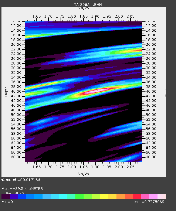
| Estimated Moho Depth: |
39.5 km |
| Estimated Crust Vp/Vs: |
1.91 |
| Assumed Crust Vp: |
6.597 km/s |
| Estimated Crust Vs: |
3.459 km/s |
| Estimated Crust Poisson's Ratio: |
0.31 |
|
| Radial Match: |
80.017166 % |
| Radial Bump: |
400 |
| Transverse Match: |
55.13763 % |
| Transverse Bump: |
400 |
| SOD ConfigId: |
2564 |
| Insert Time: |
2010-03-06 08:57:37.541 +0000 |
| GWidth: |
2.5 |
| Max Bumps: |
400 |
| Tol: |
0.001 |
|

Signal To Noise
| Channel | StoN | STA | LTA |
| TA:G06A: :BHN:20080303T14:24:10.599004Z | 0.6514675 | 1.5191554E-7 | 2.3318974E-7 |
| TA:G06A: :BHE:20080303T14:24:10.599004Z | 1.4268423 | 2.980325E-7 | 2.0887556E-7 |
| TA:G06A: :BHZ:20080303T14:24:10.599004Z | 2.1356504 | 6.7703706E-7 | 3.170168E-7 |
| Arrivals |
| Ps | 5.5 SECOND |
| PpPs | 17 SECOND |
| PsPs/PpSs | 23 SECOND |


