You are here: Home > Network List > TA - USArray Transportable Network (new EarthScope stations) Stations List
> Station G06A Carlson Farm, Grass Valley, OR, USA > Earthquake Result Viewer
G06A Carlson Farm, Grass Valley, OR, USA - Earthquake Result Viewer
| Earthquake location: |
Andreanof Islands, Aleutian Is. |
| Earthquake latitude/longitude: |
51.9/-179.2 |
| Earthquake time(UTC): |
2008/04/16 (107) 05:54:19 GMT |
| Earthquake Depth: |
13 km |
| Earthquake Magnitude: |
6.1 MB, 6.5 MS, 6.6 MW, 6.6 MW |
| Earthquake Catalog/Contributor: |
WHDF/NEIC |
|
| Network: |
TA USArray Transportable Network (new EarthScope stations) |
| Station: |
G06A Carlson Farm, Grass Valley, OR, USA |
| Lat/Lon: |
45.24 N/120.64 W |
| Elevation: |
780 m |
|
| Distance: |
38.4 deg |
| Az: |
76.092 deg |
| Baz: |
301.612 deg |
| Ray Param: |
0.075588964 |
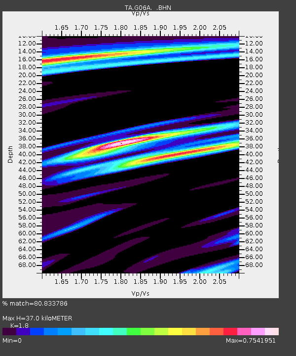
| Estimated Moho Depth: |
37.0 km |
| Estimated Crust Vp/Vs: |
1.80 |
| Assumed Crust Vp: |
6.597 km/s |
| Estimated Crust Vs: |
3.665 km/s |
| Estimated Crust Poisson's Ratio: |
0.28 |
|
| Radial Match: |
80.833786 % |
| Radial Bump: |
400 |
| Transverse Match: |
64.773056 % |
| Transverse Bump: |
400 |
| SOD ConfigId: |
2504 |
| Insert Time: |
2010-03-06 08:57:43.814 +0000 |
| GWidth: |
2.5 |
| Max Bumps: |
400 |
| Tol: |
0.001 |
|

Signal To Noise
| Channel | StoN | STA | LTA |
| TA:G06A: :BHN:20080416T06:01:09.649015Z | 4.3786263 | 8.1129184E-7 | 1.8528456E-7 |
| TA:G06A: :BHE:20080416T06:01:09.649015Z | 0.8152229 | 1.2456013E-7 | 1.5279271E-7 |
| TA:G06A: :BHZ:20080416T06:01:09.649015Z | 2.993699 | 4.7709074E-7 | 1.5936496E-7 |
| Arrivals |
| Ps | 4.8 SECOND |
| PpPs | 15 SECOND |
| PsPs/PpSs | 19 SECOND |


