You are here: Home > Network List > TA - USArray Transportable Network (new EarthScope stations) Stations List
> Station J20K Nowitna River, AK, USA > Earthquake Result Viewer
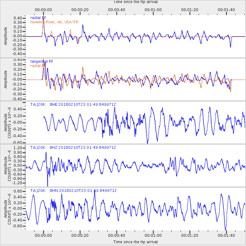
J20K Nowitna River, AK, USA - Earthquake Result Viewer
*The percent match for this event was below the threshold and hence no stack was calculated.
| Earthquake location: |
New Ireland Region, P.N.G. |
| Earthquake latitude/longitude: |
-3.8/151.9 |
| Earthquake time(UTC): |
2018/02/10 (041) 22:50:48 GMT |
| Earthquake Depth: |
268 km |
| Earthquake Magnitude: |
5.8 Mww |
| Earthquake Catalog/Contributor: |
NEIC PDE/us |
|
| Network: |
TA USArray Transportable Network (new EarthScope stations) |
| Station: |
J20K Nowitna River, AK, USA |
| Lat/Lon: |
64.18 N/154.15 W |
| Elevation: |
314 m |
|
| Distance: |
78.6 deg |
| Az: |
21.173 deg |
| Baz: |
235.375 deg |
| Ray Param: |
$rayparam |
*The percent match for this event was below the threshold and hence was not used in the summary stack. |
|
| Radial Match: |
59.098446 % |
| Radial Bump: |
347 |
| Transverse Match: |
72.065155 % |
| Transverse Bump: |
400 |
| SOD ConfigId: |
13570011 |
| Insert Time: |
2019-04-29 19:09:47.622 +0000 |
| GWidth: |
2.5 |
| Max Bumps: |
400 |
| Tol: |
0.001 |
|
Signal To Noise
| Channel | StoN | STA | LTA |
| TA:J20K: :BHZ:20180210T23:01:49.849971Z | 2.8702364 | 4.8601186E-7 | 1.6932817E-7 |
| TA:J20K: :BHN:20180210T23:01:49.849971Z | 1.2754812 | 2.6019973E-7 | 2.0400121E-7 |
| TA:J20K: :BHE:20180210T23:01:49.849971Z | 1.2515821 | 1.8859843E-7 | 1.5068801E-7 |
| Arrivals |
| Ps | |
| PpPs | |
| PsPs/PpSs | |


