You are here: Home > Network List > US - United States National Seismic Network Stations List
> Station DGMT Dagmar, Montana, USA > Earthquake Result Viewer
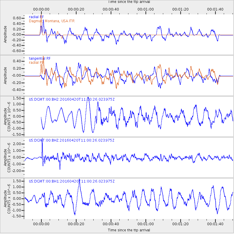
DGMT Dagmar, Montana, USA - Earthquake Result Viewer
*The percent match for this event was below the threshold and hence no stack was calculated.
| Earthquake location: |
North Atlantic Ocean |
| Earthquake latitude/longitude: |
13.2/-55.9 |
| Earthquake time(UTC): |
2016/04/20 (111) 10:51:39 GMT |
| Earthquake Depth: |
10 km |
| Earthquake Magnitude: |
5.8 MB |
| Earthquake Catalog/Contributor: |
NEIC PDE/NEIC COMCAT |
|
| Network: |
US United States National Seismic Network |
| Station: |
DGMT Dagmar, Montana, USA |
| Lat/Lon: |
48.47 N/104.20 W |
| Elevation: |
0.0 m |
|
| Distance: |
53.1 deg |
| Az: |
321.589 deg |
| Baz: |
114.604 deg |
| Ray Param: |
$rayparam |
*The percent match for this event was below the threshold and hence was not used in the summary stack. |
|
| Radial Match: |
53.424072 % |
| Radial Bump: |
363 |
| Transverse Match: |
56.721966 % |
| Transverse Bump: |
400 |
| SOD ConfigId: |
1475611 |
| Insert Time: |
2016-05-04 11:06:04.807 +0000 |
| GWidth: |
2.5 |
| Max Bumps: |
400 |
| Tol: |
0.001 |
|
Signal To Noise
| Channel | StoN | STA | LTA |
| US:DGMT:00:BHZ:20160420T11:00:26.023975Z | 2.9886804 | 7.078562E-7 | 2.3684574E-7 |
| US:DGMT:00:BH1:20160420T11:00:26.023975Z | 2.002598 | 3.4768053E-7 | 1.7361472E-7 |
| US:DGMT:00:BH2:20160420T11:00:26.023975Z | 1.4777236 | 7.991298E-7 | 5.4078436E-7 |
| Arrivals |
| Ps | |
| PpPs | |
| PsPs/PpSs | |


