You are here: Home > Network List > US - United States National Seismic Network Stations List
> Station GLMI Grayling, Michigan, USA > Earthquake Result Viewer
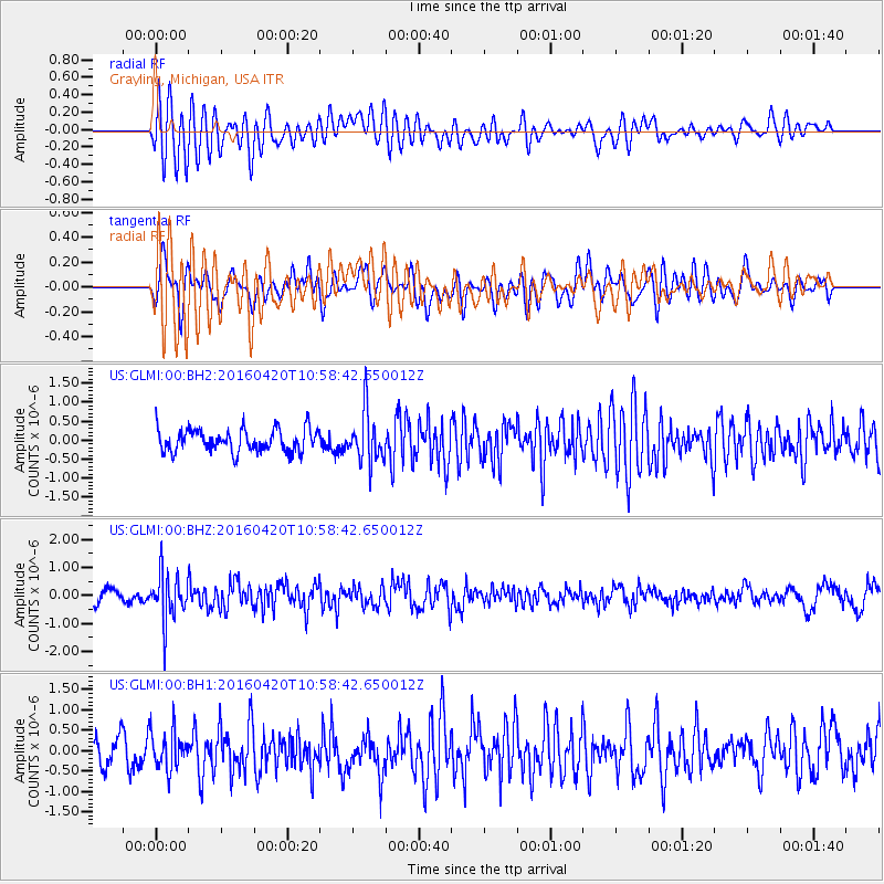
GLMI Grayling, Michigan, USA - Earthquake Result Viewer
*The percent match for this event was below the threshold and hence no stack was calculated.
| Earthquake location: |
North Atlantic Ocean |
| Earthquake latitude/longitude: |
13.2/-55.9 |
| Earthquake time(UTC): |
2016/04/20 (111) 10:51:39 GMT |
| Earthquake Depth: |
10 km |
| Earthquake Magnitude: |
5.8 MB |
| Earthquake Catalog/Contributor: |
NEIC PDE/NEIC COMCAT |
|
| Network: |
US United States National Seismic Network |
| Station: |
GLMI Grayling, Michigan, USA |
| Lat/Lon: |
44.82 N/84.62 W |
| Elevation: |
387 m |
|
| Distance: |
39.9 deg |
| Az: |
327.801 deg |
| Baz: |
133.176 deg |
| Ray Param: |
$rayparam |
*The percent match for this event was below the threshold and hence was not used in the summary stack. |
|
| Radial Match: |
64.68034 % |
| Radial Bump: |
400 |
| Transverse Match: |
64.36226 % |
| Transverse Bump: |
400 |
| SOD ConfigId: |
1475611 |
| Insert Time: |
2016-05-04 11:06:55.703 +0000 |
| GWidth: |
2.5 |
| Max Bumps: |
400 |
| Tol: |
0.001 |
|
Signal To Noise
| Channel | StoN | STA | LTA |
| US:GLMI:00:BHZ:20160420T10:58:42.650012Z | 3.115626 | 8.1563155E-7 | 2.6178736E-7 |
| US:GLMI:00:BH1:20160420T10:58:42.650012Z | 1.4089954 | 4.621691E-7 | 3.2801321E-7 |
| US:GLMI:00:BH2:20160420T10:58:42.650012Z | 2.2335362 | 6.6564263E-7 | 2.9802186E-7 |
| Arrivals |
| Ps | |
| PpPs | |
| PsPs/PpSs | |


