You are here: Home > Network List > TA - USArray Transportable Network (new EarthScope stations) Stations List
> Station MDND Maddock, ND, USA > Earthquake Result Viewer
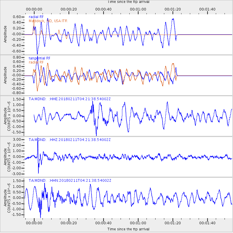
MDND Maddock, ND, USA - Earthquake Result Viewer
*The percent match for this event was below the threshold and hence no stack was calculated.
| Earthquake location: |
Near Coast Of Peru |
| Earthquake latitude/longitude: |
-16.7/-74.2 |
| Earthquake time(UTC): |
2018/02/11 (042) 04:11:09 GMT |
| Earthquake Depth: |
10 km |
| Earthquake Magnitude: |
5.4 Mww |
| Earthquake Catalog/Contributor: |
NEIC PDE/us |
|
| Network: |
TA USArray Transportable Network (new EarthScope stations) |
| Station: |
MDND Maddock, ND, USA |
| Lat/Lon: |
47.85 N/99.60 W |
| Elevation: |
479 m |
|
| Distance: |
68.2 deg |
| Az: |
341.835 deg |
| Baz: |
153.667 deg |
| Ray Param: |
$rayparam |
*The percent match for this event was below the threshold and hence was not used in the summary stack. |
|
| Radial Match: |
54.791428 % |
| Radial Bump: |
400 |
| Transverse Match: |
69.05446 % |
| Transverse Bump: |
400 |
| SOD ConfigId: |
13570011 |
| Insert Time: |
2019-04-29 19:17:36.778 +0000 |
| GWidth: |
2.5 |
| Max Bumps: |
400 |
| Tol: |
0.001 |
|
Signal To Noise
| Channel | StoN | STA | LTA |
| TA:MDND: :HHZ:20180211T04:21:38.54002Z | 4.0686727 | 1.0053179E-6 | 2.4708746E-7 |
| TA:MDND: :HHN:20180211T04:21:38.54002Z | 1.784939 | 7.2159827E-7 | 4.0427054E-7 |
| TA:MDND: :HHE:20180211T04:21:38.54002Z | 1.808806 | 5.4326927E-7 | 3.0034693E-7 |
| Arrivals |
| Ps | |
| PpPs | |
| PsPs/PpSs | |


