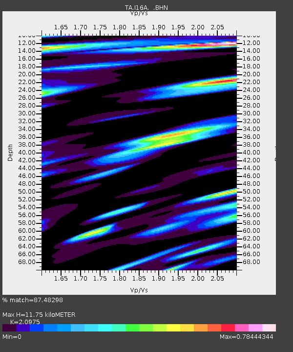
I16A Newdale, ID, USA - Earthquake Result Viewer
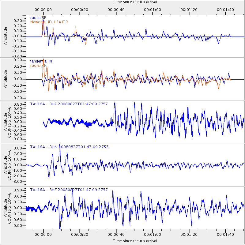
Earthquake location: Lake Baykal Region, Russia
Earthquake latitude/longitude: 51.6/104.2
Earthquake time(UTC): 2008/08/27 (240) 01:35:32 GMT
Earthquake Depth: 16 km
Earthquake Magnitude: 5.8 MB, 6.2 MS, 6.2 MW, 6.2 MW
Earthquake Catalog/Contributor: WHDF/NEIC
Network: TA USArray Transportable Network (new EarthScope stations)
Station: I16A Newdale, ID, USA
Lat/Lon: 43.88 N/111.49 W
Elevation: 1744 m
Distance: 80.0 deg
Az: 25.335 deg
Baz: 338.346 deg
Ray Param: 0.048556637
Estimated Moho Depth: 11.75 km
Estimated Crust Vp/Vs: 2.10
Assumed Crust Vp: 6.207 km/s
Estimated Crust Vs: 2.959 km/s
Estimated Crust Poisson's Ratio: 0.35
Radial Match: 87.48298 %
Radial Bump: 400
Transverse Match: 83.23391 %
Transverse Bump: 400
SOD ConfigId: 2504
Insert Time: 2010-03-06 09:00:20.392 +0000
GWidth: 2.5
Max Bumps: 400
Tol: 0.001

Signal To Noise

ChannelStoNSTALTA
TA:I16A: :BHN:20080827T01:47:09.275Z7.8221847.833778E-71.0014821E-7
TA:I16A: :BHE:20080827T01:47:09.275Z2.40442731.7717682E-77.3687744E-8
TA:I16A: :BHZ:20080827T01:47:09.275Z1.32771791.2619498E-79.504652E-8
Arrivals
Ps2.1 SECOND
PpPs5.7 SECOND
PsPs/PpSs7.9 SECOND