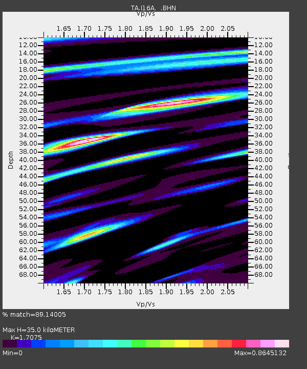
I16A Newdale, ID, USA - Earthquake Result Viewer

Earthquake location: Near Coast Of Chiapas, Mexico
Earthquake latitude/longitude: 14.4/-92.4
Earthquake time(UTC): 2008/10/16 (290) 19:41:25 GMT
Earthquake Depth: 24 km
Earthquake Magnitude: 6.1 MB, 6.6 MS, 6.7 MW, 6.6 MW
Earthquake Catalog/Contributor: WHDF/NEIC
Network: TA USArray Transportable Network (new EarthScope stations)
Station: I16A Newdale, ID, USA
Lat/Lon: 43.88 N/111.49 W
Elevation: 1744 m
Distance: 33.6 deg
Az: 334.651 deg
Baz: 144.998 deg
Ray Param: 0.07810349
Estimated Moho Depth: 35.0 km
Estimated Crust Vp/Vs: 1.71
Assumed Crust Vp: 6.207 km/s
Estimated Crust Vs: 3.635 km/s
Estimated Crust Poisson's Ratio: 0.24
Radial Match: 89.14005 %
Radial Bump: 366
Transverse Match: 76.798996 %
Transverse Bump: 363
SOD ConfigId: 2556
Insert Time: 2010-03-06 09:00:26.234 +0000
GWidth: 2.5
Max Bumps: 400
Tol: 0.001

Signal To Noise

ChannelStoNSTALTA
TA:I16A: :BHN:20081016T19:47:33.398986Z18.0646573.2429193E-61.7951734E-7
TA:I16A: :BHE:20081016T19:47:33.398986Z4.82073451.5567864E-63.2293553E-7
TA:I16A: :BHZ:20081016T19:47:33.398986Z3.6722231.2427076E-63.3840746E-7
Arrivals
Ps4.3 SECOND
PpPs14 SECOND
PsPs/PpSs18 SECOND