You are here: Home > Network List > TA - USArray Transportable Network (new EarthScope stations) Stations List
> Station I16A Newdale, ID, USA > Earthquake Result Viewer
I16A Newdale, ID, USA - Earthquake Result Viewer
| Earthquake location: |
Chile-Bolivia Border Region |
| Earthquake latitude/longitude: |
-20.0/-69.0 |
| Earthquake time(UTC): |
2008/03/24 (084) 20:39:07 GMT |
| Earthquake Depth: |
120 km |
| Earthquake Magnitude: |
5.7 MB, 6.2 MW, 6.1 MW |
| Earthquake Catalog/Contributor: |
WHDF/NEIC |
|
| Network: |
TA USArray Transportable Network (new EarthScope stations) |
| Station: |
I16A Newdale, ID, USA |
| Lat/Lon: |
43.88 N/111.49 W |
| Elevation: |
1744 m |
|
| Distance: |
74.6 deg |
| Az: |
329.534 deg |
| Baz: |
138.764 deg |
| Ray Param: |
0.051940322 |
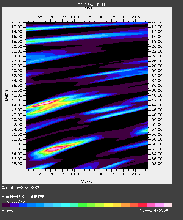
| Estimated Moho Depth: |
43.0 km |
| Estimated Crust Vp/Vs: |
1.68 |
| Assumed Crust Vp: |
6.207 km/s |
| Estimated Crust Vs: |
3.7 km/s |
| Estimated Crust Poisson's Ratio: |
0.22 |
|
| Radial Match: |
80.00882 % |
| Radial Bump: |
400 |
| Transverse Match: |
53.609665 % |
| Transverse Bump: |
389 |
| SOD ConfigId: |
2504 |
| Insert Time: |
2010-03-06 09:00:49.427 +0000 |
| GWidth: |
2.5 |
| Max Bumps: |
400 |
| Tol: |
0.001 |
|
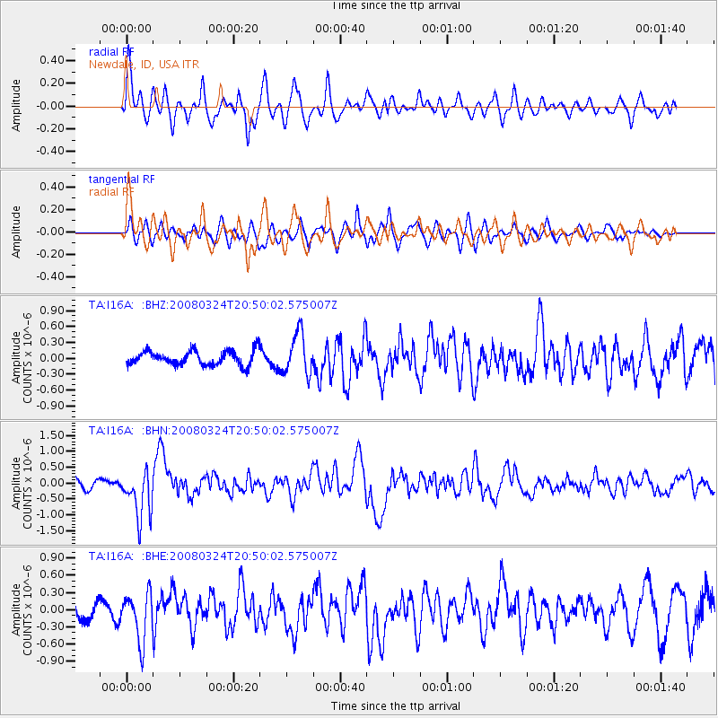
Signal To Noise
| Channel | StoN | STA | LTA |
| TA:I16A: :BHN:20080324T20:50:02.575007Z | 4.869219 | 7.549161E-7 | 1.5503844E-7 |
| TA:I16A: :BHE:20080324T20:50:02.575007Z | 2.945826 | 4.1886327E-7 | 1.4218872E-7 |
| TA:I16A: :BHZ:20080324T20:50:02.575007Z | 2.8884037 | 3.8965194E-7 | 1.3490218E-7 |
| Arrivals |
| Ps | 4.8 SECOND |
| PpPs | 18 SECOND |
| PsPs/PpSs | 23 SECOND |


