You are here: Home > Network List > TA - USArray Transportable Network (new EarthScope stations) Stations List
> Station I16A Newdale, ID, USA > Earthquake Result Viewer
I16A Newdale, ID, USA - Earthquake Result Viewer
| Earthquake location: |
East Of Kuril Islands |
| Earthquake latitude/longitude: |
46.9/155.2 |
| Earthquake time(UTC): |
2009/01/15 (015) 17:49:39 GMT |
| Earthquake Depth: |
36 km |
| Earthquake Magnitude: |
6.9 MB, 7.5 MS, 7.4 MW, 7.4 MW |
| Earthquake Catalog/Contributor: |
WHDF/NEIC |
|
| Network: |
TA USArray Transportable Network (new EarthScope stations) |
| Station: |
I16A Newdale, ID, USA |
| Lat/Lon: |
43.88 N/111.49 W |
| Elevation: |
1744 m |
|
| Distance: |
61.8 deg |
| Az: |
55.037 deg |
| Baz: |
308.95 deg |
| Ray Param: |
0.060612194 |
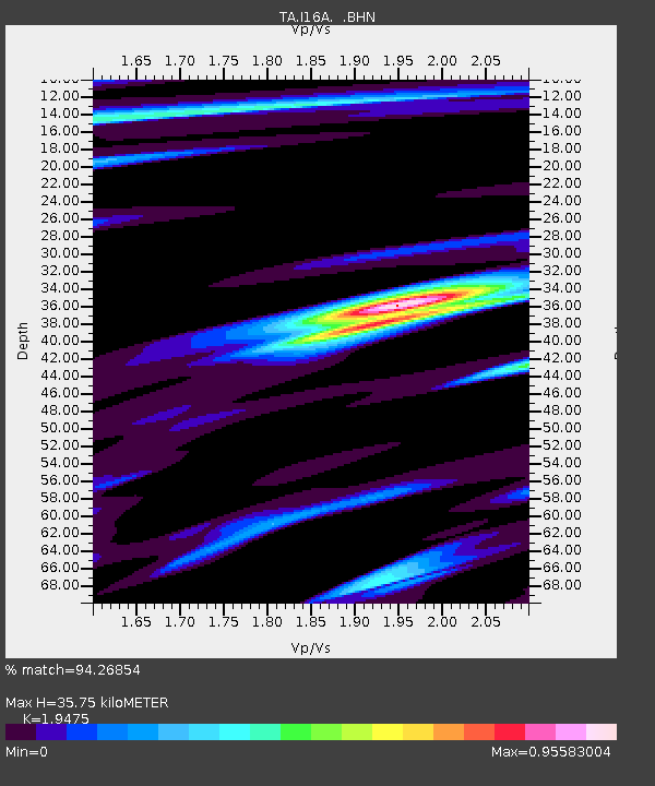
| Estimated Moho Depth: |
35.75 km |
| Estimated Crust Vp/Vs: |
1.95 |
| Assumed Crust Vp: |
6.207 km/s |
| Estimated Crust Vs: |
3.187 km/s |
| Estimated Crust Poisson's Ratio: |
0.32 |
|
| Radial Match: |
94.26854 % |
| Radial Bump: |
383 |
| Transverse Match: |
91.06758 % |
| Transverse Bump: |
378 |
| SOD ConfigId: |
2834 |
| Insert Time: |
2010-03-06 09:00:51.907 +0000 |
| GWidth: |
2.5 |
| Max Bumps: |
400 |
| Tol: |
0.001 |
|
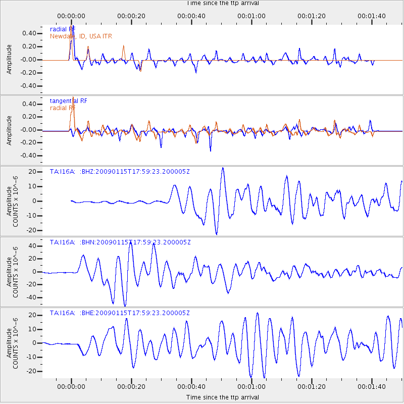
Signal To Noise
| Channel | StoN | STA | LTA |
| TA:I16A: :BHN:20090115T17:59:23.200005Z | 25.170595 | 1.3179711E-5 | 5.236154E-7 |
| TA:I16A: :BHE:20090115T17:59:23.200005Z | 7.146589 | 3.9143083E-6 | 5.4771704E-7 |
| TA:I16A: :BHZ:20090115T17:59:23.200005Z | 10.599195 | 5.40845E-6 | 5.102699E-7 |
| Arrivals |
| Ps | 5.7 SECOND |
| PpPs | 16 SECOND |
| PsPs/PpSs | 22 SECOND |


