You are here: Home > Network List > TA - USArray Transportable Network (new EarthScope stations) Stations List
> Station I16A Newdale, ID, USA > Earthquake Result Viewer
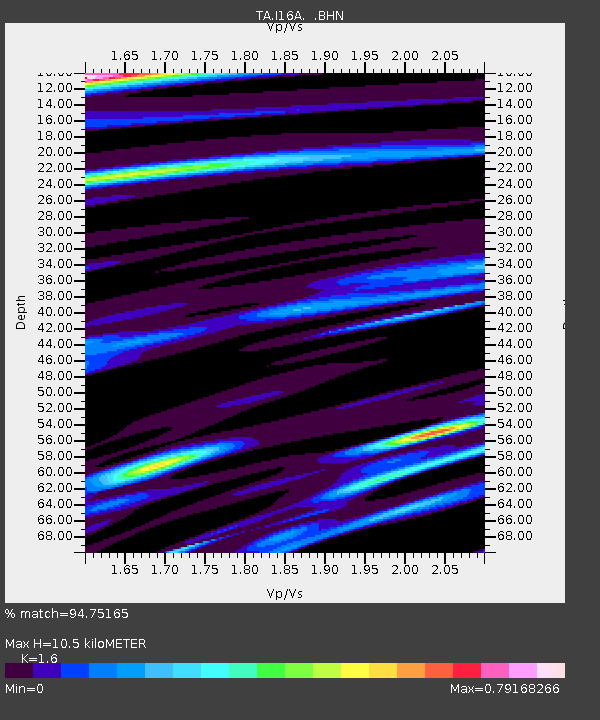
I16A Newdale, ID, USA - Earthquake Result Viewer
| Earthquake location: |
Kermadec Islands Region |
| Earthquake latitude/longitude: |
-27.4/-176.3 |
| Earthquake time(UTC): |
2009/02/18 (049) 21:53:45 GMT |
| Earthquake Depth: |
25 km |
| Earthquake Magnitude: |
6.8 MB, 7.2 MS, 6.9 MW, 6.9 MW |
| Earthquake Catalog/Contributor: |
WHDF/NEIC |
|
| Network: |
TA USArray Transportable Network (new EarthScope stations) |
| Station: |
I16A Newdale, ID, USA |
| Lat/Lon: |
43.88 N/111.49 W |
| Elevation: |
1744 m |
|
| Distance: |
92.5 deg |
| Az: |
40.934 deg |
| Baz: |
233.641 deg |
| Ray Param: |
0.04144443 |
| Estimated Moho Depth: |
10.5 km |
| Estimated Crust Vp/Vs: |
1.60 |
| Assumed Crust Vp: |
6.207 km/s |
| Estimated Crust Vs: |
3.879 km/s |
| Estimated Crust Poisson's Ratio: |
0.18 |
|
| Radial Match: |
94.75165 % |
| Radial Bump: |
289 |
| Transverse Match: |
91.803764 % |
| Transverse Bump: |
400 |
| SOD ConfigId: |
2658 |
| Insert Time: |
2010-03-06 09:00:53.595 +0000 |
| GWidth: |
2.5 |
| Max Bumps: |
400 |
| Tol: |
0.001 |
|

Signal To Noise
| Channel | StoN | STA | LTA |
| TA:I16A: :BHN:20090218T22:06:22.375027Z | 11.178805 | 1.6311992E-6 | 1.4591893E-7 |
| TA:I16A: :BHE:20090218T22:06:22.375027Z | 1.1620525 | 3.7749743E-7 | 3.2485403E-7 |
| TA:I16A: :BHZ:20090218T22:06:22.375027Z | 1.3053764 | 3.384699E-7 | 2.5928912E-7 |
| Arrivals |
| Ps | 1.0 SECOND |
| PpPs | 4.3 SECOND |
| PsPs/PpSs | 5.3 SECOND |


