You are here: Home > Network List > TA - USArray Transportable Network (new EarthScope stations) Stations List
> Station I16A Newdale, ID, USA > Earthquake Result Viewer
I16A Newdale, ID, USA - Earthquake Result Viewer
| Earthquake location: |
Tonga Islands |
| Earthquake latitude/longitude: |
-20.8/-174.3 |
| Earthquake time(UTC): |
2009/07/30 (211) 20:05:34 GMT |
| Earthquake Depth: |
10 km |
| Earthquake Magnitude: |
5.9 MB, 5.7 MS, 5.8 MW, 5.7 MW |
| Earthquake Catalog/Contributor: |
WHDF/NEIC |
|
| Network: |
TA USArray Transportable Network (new EarthScope stations) |
| Station: |
I16A Newdale, ID, USA |
| Lat/Lon: |
43.88 N/111.49 W |
| Elevation: |
1744 m |
|
| Distance: |
86.3 deg |
| Az: |
40.119 deg |
| Baz: |
236.45 deg |
| Ray Param: |
0.04417583 |
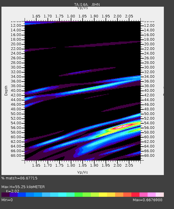
| Estimated Moho Depth: |
55.25 km |
| Estimated Crust Vp/Vs: |
2.02 |
| Assumed Crust Vp: |
6.207 km/s |
| Estimated Crust Vs: |
3.073 km/s |
| Estimated Crust Poisson's Ratio: |
0.34 |
|
| Radial Match: |
86.67715 % |
| Radial Bump: |
400 |
| Transverse Match: |
61.929787 % |
| Transverse Bump: |
400 |
| SOD ConfigId: |
2622 |
| Insert Time: |
2010-03-06 09:00:56.905 +0000 |
| GWidth: |
2.5 |
| Max Bumps: |
400 |
| Tol: |
0.001 |
|
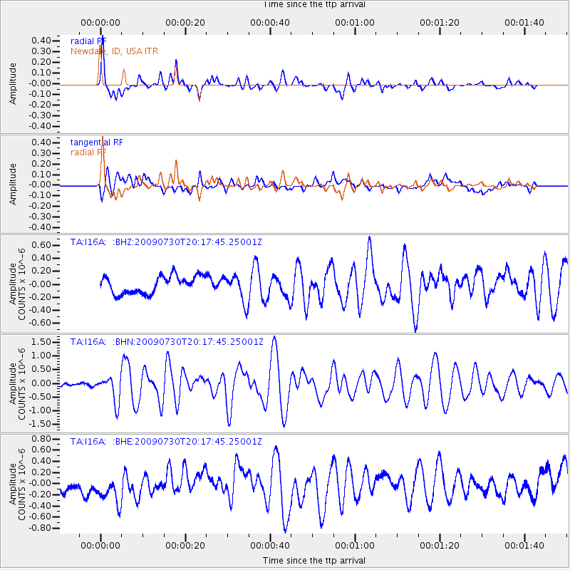
Signal To Noise
| Channel | StoN | STA | LTA |
| TA:I16A: :BHN:20090730T20:17:45.25001Z | 7.258205 | 4.912275E-7 | 6.7678926E-8 |
| TA:I16A: :BHE:20090730T20:17:45.25001Z | 2.257143 | 3.4160533E-7 | 1.5134411E-7 |
| TA:I16A: :BHZ:20090730T20:17:45.25001Z | 1.611594 | 2.1416616E-7 | 1.328909E-7 |
| Arrivals |
| Ps | 9.3 SECOND |
| PpPs | 26 SECOND |
| PsPs/PpSs | 36 SECOND |


