You are here: Home > Network List > TA - USArray Transportable Network (new EarthScope stations) Stations List
> Station I16A Newdale, ID, USA > Earthquake Result Viewer
I16A Newdale, ID, USA - Earthquake Result Viewer

| Earthquake location: |
Kyushu, Japan |
| Earthquake latitude/longitude: |
31.1/130.0 |
| Earthquake time(UTC): |
2009/09/03 (246) 13:26:18 GMT |
| Earthquake Depth: |
166 km |
| Earthquake Magnitude: |
5.9 MB, 6.2 MW, 6.2 MW |
| Earthquake Catalog/Contributor: |
WHDF/NEIC |
|
| Network: |
TA USArray Transportable Network (new EarthScope stations) |
| Station: |
I16A Newdale, ID, USA |
| Lat/Lon: |
43.88 N/111.49 W |
| Elevation: |
1744 m |
|
| Distance: |
86.6 deg |
| Az: |
39.549 deg |
| Baz: |
310.98 deg |
| Ray Param: |
0.043568704 |
| Estimated Moho Depth: |
51.0 km |
| Estimated Crust Vp/Vs: |
1.88 |
| Assumed Crust Vp: |
6.207 km/s |
| Estimated Crust Vs: |
3.306 km/s |
| Estimated Crust Poisson's Ratio: |
0.30 |
|
| Radial Match: |
92.964096 % |
| Radial Bump: |
400 |
| Transverse Match: |
81.22643 % |
| Transverse Bump: |
400 |
| SOD ConfigId: |
2622 |
| Insert Time: |
2010-03-06 09:01:10.874 +0000 |
| GWidth: |
2.5 |
| Max Bumps: |
400 |
| Tol: |
0.001 |
|
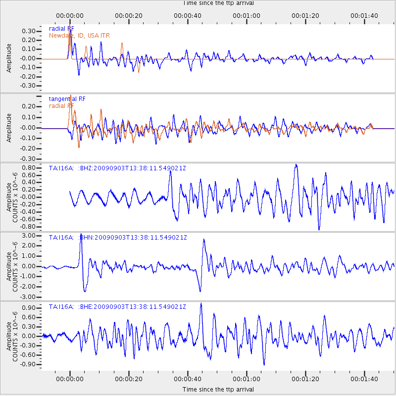
Signal To Noise
| Channel | StoN | STA | LTA |
| TA:I16A: :BHN:20090903T13:38:11.549021Z | 18.698423 | 1.1510937E-6 | 6.1561E-8 |
| TA:I16A: :BHE:20090903T13:38:11.549021Z | 2.1655986 | 1.5595968E-7 | 7.201689E-8 |
| TA:I16A: :BHZ:20090903T13:38:11.549021Z | 2.0208187 | 2.603225E-7 | 1.2882032E-7 |
| Arrivals |
| Ps | 7.4 SECOND |
| PpPs | 23 SECOND |
| PsPs/PpSs | 31 SECOND |


