You are here: Home > Network List > CI - Caltech Regional Seismic Network Stations List
> Station MPM Manuel Prospect Mine, California, USA > Earthquake Result Viewer
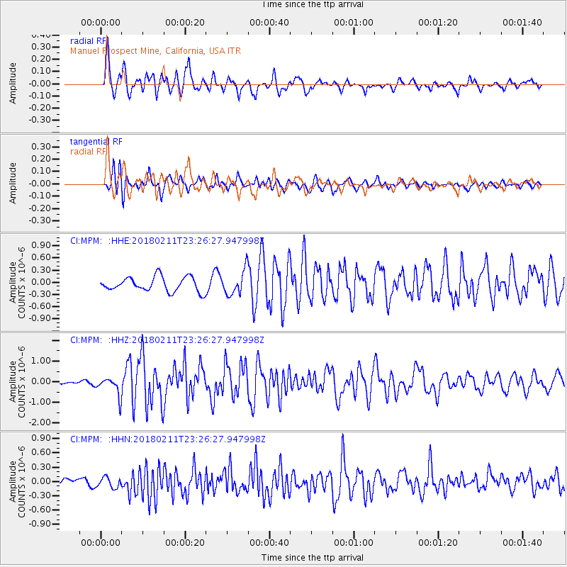
MPM Manuel Prospect Mine, California, USA - Earthquake Result Viewer
*The percent match for this event was below the threshold and hence no stack was calculated.
| Earthquake location: |
South Of Mariana Islands |
| Earthquake latitude/longitude: |
13.8/146.5 |
| Earthquake time(UTC): |
2018/02/11 (042) 23:14:18 GMT |
| Earthquake Depth: |
42 km |
| Earthquake Magnitude: |
6.2 Mi |
| Earthquake Catalog/Contributor: |
NEIC PDE/pt |
|
| Network: |
CI Caltech Regional Seismic Network |
| Station: |
MPM Manuel Prospect Mine, California, USA |
| Lat/Lon: |
36.06 N/117.49 W |
| Elevation: |
185 m |
|
| Distance: |
86.7 deg |
| Az: |
53.822 deg |
| Baz: |
284.617 deg |
| Ray Param: |
$rayparam |
*The percent match for this event was below the threshold and hence was not used in the summary stack. |
|
| Radial Match: |
81.37496 % |
| Radial Bump: |
400 |
| Transverse Match: |
77.58007 % |
| Transverse Bump: |
400 |
| SOD ConfigId: |
13570011 |
| Insert Time: |
2019-04-29 19:28:17.611 +0000 |
| GWidth: |
2.5 |
| Max Bumps: |
400 |
| Tol: |
0.001 |
|
Signal To Noise
| Channel | StoN | STA | LTA |
| CI:MPM: :HHZ:20180211T23:26:27.947998Z | 10.176026 | 4.704712E-7 | 4.6233293E-8 |
| CI:MPM: :HHN:20180211T23:26:27.947998Z | 1.449488 | 1.114564E-7 | 7.689363E-8 |
| CI:MPM: :HHE:20180211T23:26:27.947998Z | 1.507872 | 2.4503845E-7 | 1.6250613E-7 |
| Arrivals |
| Ps | |
| PpPs | |
| PsPs/PpSs | |


