You are here: Home > Network List > TA - USArray Transportable Network (new EarthScope stations) Stations List
> Station I16A Newdale, ID, USA > Earthquake Result Viewer
I16A Newdale, ID, USA - Earthquake Result Viewer
| Earthquake location: |
Southern Peru |
| Earthquake latitude/longitude: |
-15.0/-70.4 |
| Earthquake time(UTC): |
2009/07/12 (193) 06:12:47 GMT |
| Earthquake Depth: |
199 km |
| Earthquake Magnitude: |
5.7 MB, 6.1 MW, 6.1 MW |
| Earthquake Catalog/Contributor: |
WHDF/NEIC |
|
| Network: |
TA USArray Transportable Network (new EarthScope stations) |
| Station: |
I16A Newdale, ID, USA |
| Lat/Lon: |
43.88 N/111.49 W |
| Elevation: |
1744 m |
|
| Distance: |
69.6 deg |
| Az: |
329.558 deg |
| Baz: |
137.396 deg |
| Ray Param: |
0.05498876 |
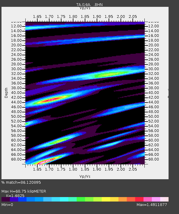
| Estimated Moho Depth: |
68.75 km |
| Estimated Crust Vp/Vs: |
1.68 |
| Assumed Crust Vp: |
6.207 km/s |
| Estimated Crust Vs: |
3.689 km/s |
| Estimated Crust Poisson's Ratio: |
0.23 |
|
| Radial Match: |
86.120895 % |
| Radial Bump: |
400 |
| Transverse Match: |
82.28454 % |
| Transverse Bump: |
400 |
| SOD ConfigId: |
2648 |
| Insert Time: |
2010-03-06 09:01:38.949 +0000 |
| GWidth: |
2.5 |
| Max Bumps: |
400 |
| Tol: |
0.001 |
|
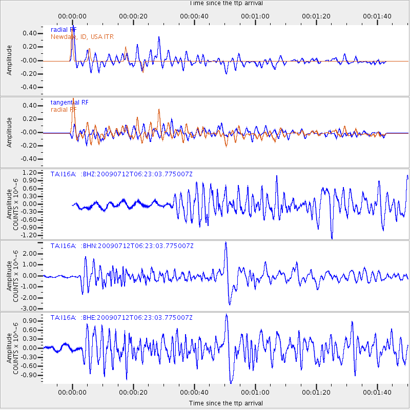
Signal To Noise
| Channel | StoN | STA | LTA |
| TA:I16A: :BHN:20090712T06:23:03.775007Z | 10.068417 | 7.187296E-7 | 7.138457E-8 |
| TA:I16A: :BHE:20090712T06:23:03.775007Z | 2.896465 | 2.3444986E-7 | 8.0943444E-8 |
| TA:I16A: :BHZ:20090712T06:23:03.775007Z | 1.9129659 | 1.8730235E-7 | 9.791202E-8 |
| Arrivals |
| Ps | 7.8 SECOND |
| PpPs | 29 SECOND |
| PsPs/PpSs | 36 SECOND |


