You are here: Home > Network List > TA - USArray Transportable Network (new EarthScope stations) Stations List
> Station I16A Newdale, ID, USA > Earthquake Result Viewer
I16A Newdale, ID, USA - Earthquake Result Viewer
| Earthquake location: |
Chile-Argentina Border Region |
| Earthquake latitude/longitude: |
-24.8/-68.5 |
| Earthquake time(UTC): |
2007/11/21 (325) 12:55:05 GMT |
| Earthquake Depth: |
115 km |
| Earthquake Magnitude: |
5.6 MB, 5.8 MW, 5.8 MW |
| Earthquake Catalog/Contributor: |
WHDF/NEIC |
|
| Network: |
TA USArray Transportable Network (new EarthScope stations) |
| Station: |
I16A Newdale, ID, USA |
| Lat/Lon: |
43.88 N/111.49 W |
| Elevation: |
1744 m |
|
| Distance: |
78.9 deg |
| Az: |
329.82 deg |
| Baz: |
140.821 deg |
| Ray Param: |
0.049053043 |
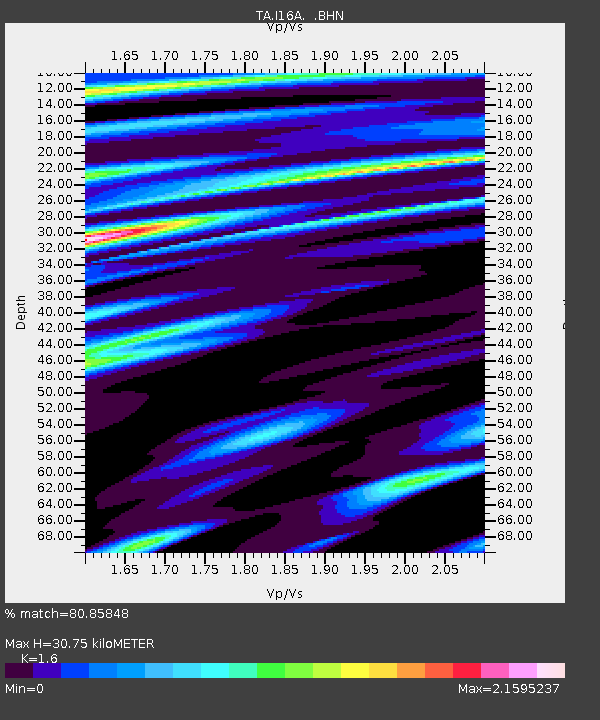
| Estimated Moho Depth: |
30.75 km |
| Estimated Crust Vp/Vs: |
1.60 |
| Assumed Crust Vp: |
6.207 km/s |
| Estimated Crust Vs: |
3.879 km/s |
| Estimated Crust Poisson's Ratio: |
0.18 |
|
| Radial Match: |
80.85848 % |
| Radial Bump: |
400 |
| Transverse Match: |
69.2598 % |
| Transverse Bump: |
400 |
| SOD ConfigId: |
2564 |
| Insert Time: |
2010-03-06 09:01:50.685 +0000 |
| GWidth: |
2.5 |
| Max Bumps: |
400 |
| Tol: |
0.001 |
|
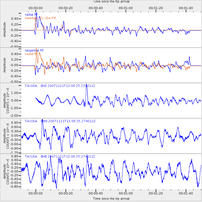
Signal To Noise
| Channel | StoN | STA | LTA |
| TA:I16A: :BHN:20071121T13:06:25.274011Z | 1.8221766 | 5.191426E-7 | 2.8490248E-7 |
| TA:I16A: :BHE:20071121T13:06:25.274011Z | 1.863298 | 4.22111E-7 | 2.265397E-7 |
| TA:I16A: :BHZ:20071121T13:06:25.274011Z | 2.567275 | 8.4754055E-7 | 3.3013234E-7 |
| Arrivals |
| Ps | 3.1 SECOND |
| PpPs | 13 SECOND |
| PsPs/PpSs | 16 SECOND |


