You are here: Home > Network List > TA - USArray Transportable Network (new EarthScope stations) Stations List
> Station I16A Newdale, ID, USA > Earthquake Result Viewer
I16A Newdale, ID, USA - Earthquake Result Viewer
| Earthquake location: |
South Of Fiji Islands |
| Earthquake latitude/longitude: |
-25.8/179.5 |
| Earthquake time(UTC): |
2007/10/16 (289) 21:05:43 GMT |
| Earthquake Depth: |
509 km |
| Earthquake Magnitude: |
6.2 MB, 6.6 MW, 6.5 MW |
| Earthquake Catalog/Contributor: |
WHDF/NEIC |
|
| Network: |
TA USArray Transportable Network (new EarthScope stations) |
| Station: |
I16A Newdale, ID, USA |
| Lat/Lon: |
43.88 N/111.49 W |
| Elevation: |
1744 m |
|
| Distance: |
93.7 deg |
| Az: |
42.569 deg |
| Baz: |
237.505 deg |
| Ray Param: |
0.04075196 |
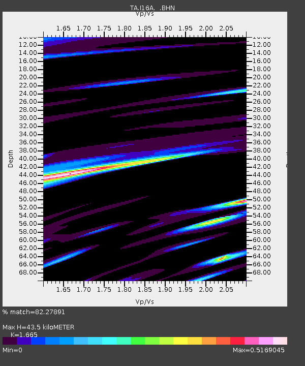
| Estimated Moho Depth: |
43.5 km |
| Estimated Crust Vp/Vs: |
1.66 |
| Assumed Crust Vp: |
6.207 km/s |
| Estimated Crust Vs: |
3.728 km/s |
| Estimated Crust Poisson's Ratio: |
0.22 |
|
| Radial Match: |
82.27891 % |
| Radial Bump: |
400 |
| Transverse Match: |
77.75647 % |
| Transverse Bump: |
400 |
| SOD ConfigId: |
2564 |
| Insert Time: |
2010-03-06 09:01:54.047 +0000 |
| GWidth: |
2.5 |
| Max Bumps: |
400 |
| Tol: |
0.001 |
|
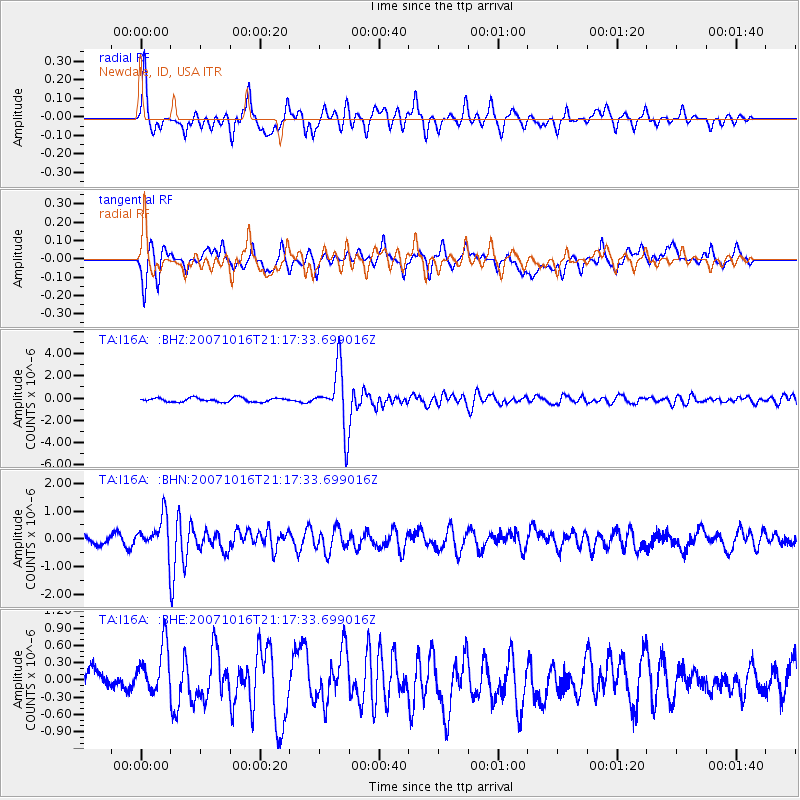
Signal To Noise
| Channel | StoN | STA | LTA |
| TA:I16A: :BHN:20071016T21:17:33.699016Z | 3.1307328 | 6.268001E-7 | 2.0020876E-7 |
| TA:I16A: :BHE:20071016T21:17:33.699016Z | 2.3183374 | 4.205078E-7 | 1.8138334E-7 |
| TA:I16A: :BHZ:20071016T21:17:33.699016Z | 14.692529 | 2.6575237E-6 | 1.8087587E-7 |
| Arrivals |
| Ps | 4.8 SECOND |
| PpPs | 18 SECOND |
| PsPs/PpSs | 23 SECOND |


