You are here: Home > Network List > TA - USArray Transportable Network (new EarthScope stations) Stations List
> Station I16A Newdale, ID, USA > Earthquake Result Viewer
I16A Newdale, ID, USA - Earthquake Result Viewer
| Earthquake location: |
Loyalty Islands |
| Earthquake latitude/longitude: |
-20.1/168.9 |
| Earthquake time(UTC): |
2008/04/09 (100) 12:46:12 GMT |
| Earthquake Depth: |
33 km |
| Earthquake Magnitude: |
6.3 MB, 7.3 MS, 7.3 MW, 7.3 MW |
| Earthquake Catalog/Contributor: |
WHDF/NEIC |
|
| Network: |
TA USArray Transportable Network (new EarthScope stations) |
| Station: |
I16A Newdale, ID, USA |
| Lat/Lon: |
43.88 N/111.49 W |
| Elevation: |
1744 m |
|
| Distance: |
96.5 deg |
| Az: |
45.72 deg |
| Baz: |
248.529 deg |
| Ray Param: |
0.040481605 |
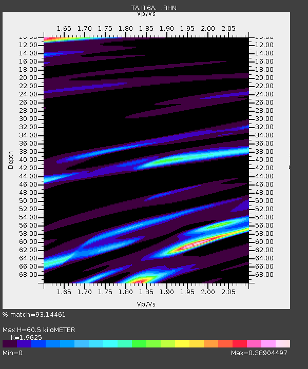
| Estimated Moho Depth: |
60.5 km |
| Estimated Crust Vp/Vs: |
1.96 |
| Assumed Crust Vp: |
6.207 km/s |
| Estimated Crust Vs: |
3.163 km/s |
| Estimated Crust Poisson's Ratio: |
0.32 |
|
| Radial Match: |
93.14461 % |
| Radial Bump: |
277 |
| Transverse Match: |
90.35909 % |
| Transverse Bump: |
340 |
| SOD ConfigId: |
2504 |
| Insert Time: |
2010-03-06 09:02:05.184 +0000 |
| GWidth: |
2.5 |
| Max Bumps: |
400 |
| Tol: |
0.001 |
|
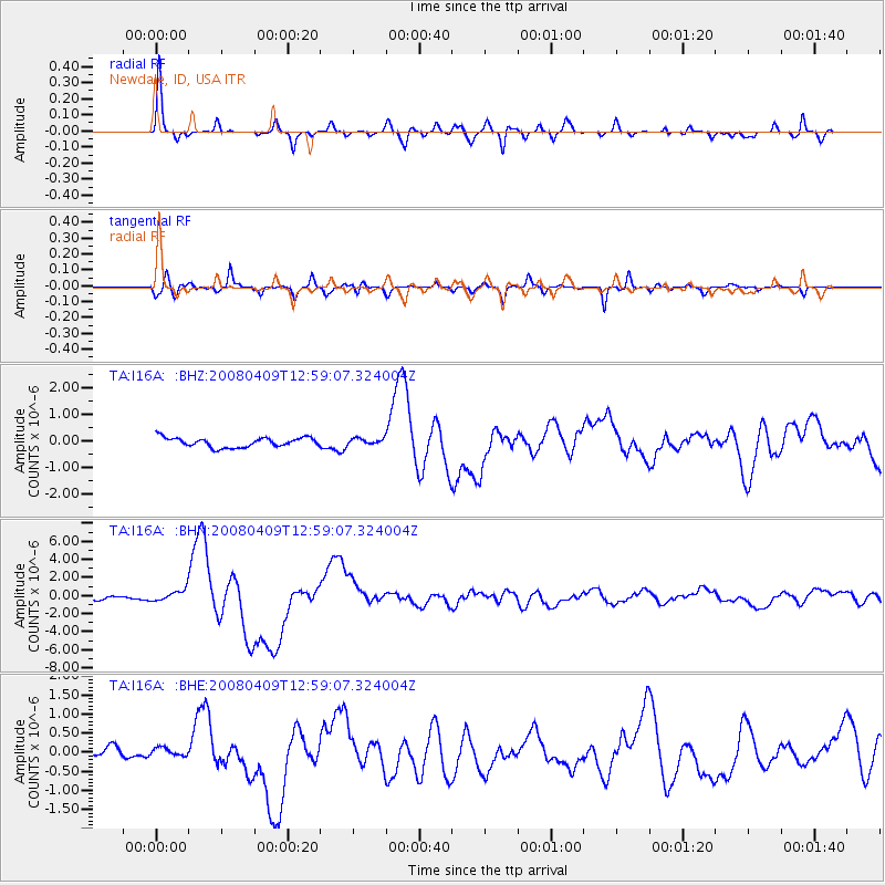
Signal To Noise
| Channel | StoN | STA | LTA |
| TA:I16A: :BHN:20080409T12:59:07.324004Z | 2.3653722 | 6.550918E-7 | 2.7695083E-7 |
| TA:I16A: :BHE:20080409T12:59:07.324004Z | 0.7998061 | 1.3812269E-7 | 1.7269521E-7 |
| TA:I16A: :BHZ:20080409T12:59:07.324004Z | 0.6766796 | 1.214305E-7 | 1.794505E-7 |
| Arrivals |
| Ps | 9.5 SECOND |
| PpPs | 28 SECOND |
| PsPs/PpSs | 38 SECOND |


