You are here: Home > Network List > TA - USArray Transportable Network (new EarthScope stations) Stations List
> Station 109C Camp Elliot, Mirimar, CA, USA > Earthquake Result Viewer
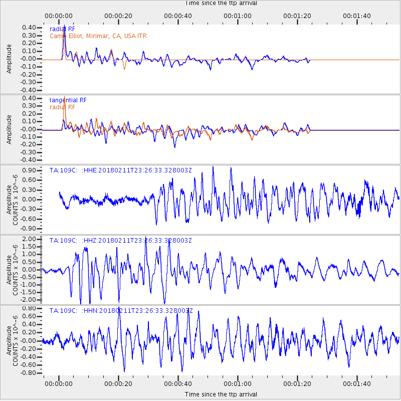
109C Camp Elliot, Mirimar, CA, USA - Earthquake Result Viewer
*The percent match for this event was below the threshold and hence no stack was calculated.
| Earthquake location: |
South Of Mariana Islands |
| Earthquake latitude/longitude: |
13.8/146.5 |
| Earthquake time(UTC): |
2018/02/11 (042) 23:14:18 GMT |
| Earthquake Depth: |
42 km |
| Earthquake Magnitude: |
6.2 Mi |
| Earthquake Catalog/Contributor: |
NEIC PDE/pt |
|
| Network: |
TA USArray Transportable Network (new EarthScope stations) |
| Station: |
109C Camp Elliot, Mirimar, CA, USA |
| Lat/Lon: |
32.89 N/117.11 W |
| Elevation: |
150 m |
|
| Distance: |
87.8 deg |
| Az: |
56.801 deg |
| Baz: |
284.975 deg |
| Ray Param: |
$rayparam |
*The percent match for this event was below the threshold and hence was not used in the summary stack. |
|
| Radial Match: |
84.66235 % |
| Radial Bump: |
326 |
| Transverse Match: |
84.94275 % |
| Transverse Bump: |
384 |
| SOD ConfigId: |
13570011 |
| Insert Time: |
2019-04-29 19:31:18.793 +0000 |
| GWidth: |
2.5 |
| Max Bumps: |
400 |
| Tol: |
0.001 |
|
Signal To Noise
| Channel | StoN | STA | LTA |
| TA:109C: :HHZ:20180211T23:26:33.328003Z | 2.1772082 | 5.0024886E-7 | 2.2976621E-7 |
| TA:109C: :HHN:20180211T23:26:33.328003Z | 1.4535307 | 1.13461454E-7 | 7.80592E-8 |
| TA:109C: :HHE:20180211T23:26:33.328003Z | 2.3089132 | 2.2497733E-7 | 9.743862E-8 |
| Arrivals |
| Ps | |
| PpPs | |
| PsPs/PpSs | |


