You are here: Home > Network List > WY - Yellowstone Wyoming Seismic Network Stations List
> Station YHH Holmes Hill, YNP, WY, USA > Earthquake Result Viewer
YHH Holmes Hill, YNP, WY, USA - Earthquake Result Viewer
*The percent match for this event was below the threshold and hence no stack was calculated.
| Earthquake location: |
North Atlantic Ocean |
| Earthquake latitude/longitude: |
13.2/-55.9 |
| Earthquake time(UTC): |
2016/04/20 (111) 10:51:39 GMT |
| Earthquake Depth: |
10 km |
| Earthquake Magnitude: |
5.8 MB |
| Earthquake Catalog/Contributor: |
NEIC PDE/NEIC COMCAT |
|
| Network: |
WY Yellowstone Wyoming Seismic Network |
| Station: |
YHH Holmes Hill, YNP, WY, USA |
| Lat/Lon: |
44.79 N/110.85 W |
| Elevation: |
2717 m |
|
| Distance: |
56.1 deg |
| Az: |
315.398 deg |
| Baz: |
106.185 deg |
| Ray Param: |
$rayparam |
*The percent match for this event was below the threshold and hence was not used in the summary stack. |
|
| Radial Match: |
70.59156 % |
| Radial Bump: |
400 |
| Transverse Match: |
73.89645 % |
| Transverse Bump: |
400 |
| SOD ConfigId: |
1475611 |
| Insert Time: |
2016-05-04 11:12:35.375 +0000 |
| GWidth: |
2.5 |
| Max Bumps: |
400 |
| Tol: |
0.001 |
|
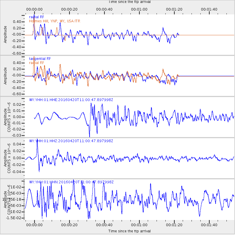
Signal To Noise
| Channel | StoN | STA | LTA |
| WY:YHH:01:HHZ:20160420T11:00:47.897998Z | 5.3569174 | 1.8873155E-8 | 3.5231373E-9 |
| WY:YHH:01:HHN:20160420T11:00:47.897998Z | 1.7590071 | 6.008749E-9 | 3.4159893E-9 |
| WY:YHH:01:HHE:20160420T11:00:47.897998Z | 3.5930538 | 1.3861881E-8 | 3.8579664E-9 |
| Arrivals |
| Ps | |
| PpPs | |
| PsPs/PpSs | |


