You are here: Home > Network List > TA - USArray Transportable Network (new EarthScope stations) Stations List
> Station I16A Newdale, ID, USA > Earthquake Result Viewer
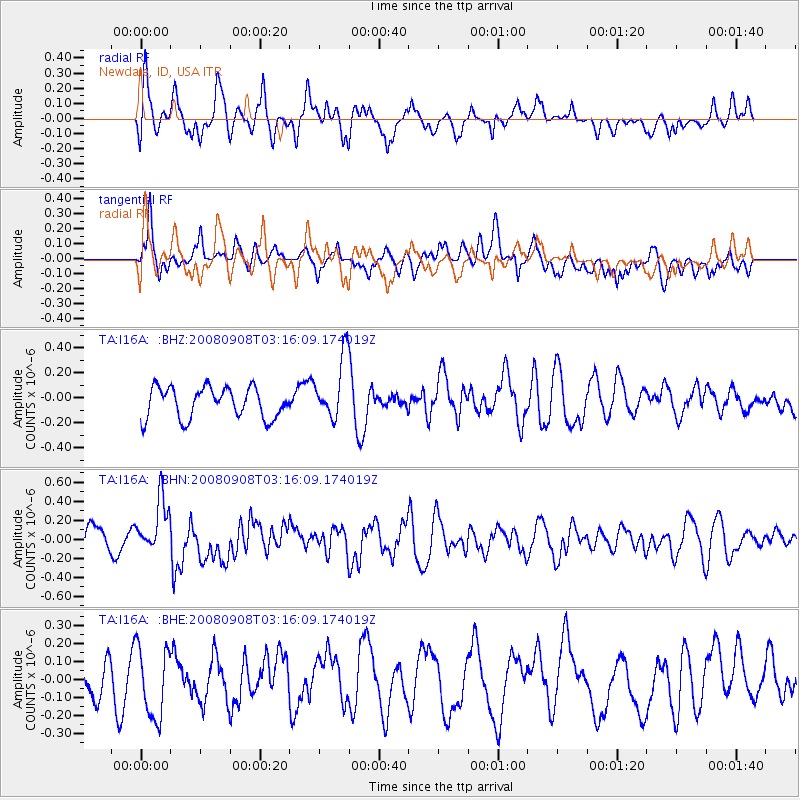
I16A Newdale, ID, USA - Earthquake Result Viewer
*The percent match for this event was below the threshold and hence no stack was calculated.
| Earthquake location: |
Vanuatu Islands |
| Earthquake latitude/longitude: |
-20.0/169.1 |
| Earthquake time(UTC): |
2008/09/08 (252) 03:03:15 GMT |
| Earthquake Depth: |
36 km |
| Earthquake Magnitude: |
6.0 MB, 5.8 MS, 6.2 MW, 6.2 MW |
| Earthquake Catalog/Contributor: |
WHDF/NEIC |
|
| Network: |
TA USArray Transportable Network (new EarthScope stations) |
| Station: |
I16A Newdale, ID, USA |
| Lat/Lon: |
43.88 N/111.49 W |
| Elevation: |
1744 m |
|
| Distance: |
96.3 deg |
| Az: |
45.654 deg |
| Baz: |
248.463 deg |
| Ray Param: |
$rayparam |
*The percent match for this event was below the threshold and hence was not used in the summary stack. |
|
| Radial Match: |
61.486286 % |
| Radial Bump: |
400 |
| Transverse Match: |
49.77514 % |
| Transverse Bump: |
400 |
| SOD ConfigId: |
2560 |
| Insert Time: |
2010-03-06 09:02:29.764 +0000 |
| GWidth: |
2.5 |
| Max Bumps: |
400 |
| Tol: |
0.001 |
|
Signal To Noise
| Channel | StoN | STA | LTA |
| TA:I16A: :BHN:20080908T03:16:09.174019Z | 2.9693923 | 2.8069346E-7 | 9.452893E-8 |
| TA:I16A: :BHE:20080908T03:16:09.174019Z | 1.2263716 | 1.9902672E-7 | 1.6228907E-7 |
| TA:I16A: :BHZ:20080908T03:16:09.174019Z | 2.049217 | 2.5064108E-7 | 1.2231067E-7 |
| Arrivals |
| Ps | |
| PpPs | |
| PsPs/PpSs | |


