You are here: Home > Network List > TA - USArray Transportable Network (new EarthScope stations) Stations List
> Station D25K Kavik River, AK, USA > Earthquake Result Viewer
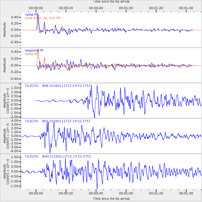
D25K Kavik River, AK, USA - Earthquake Result Viewer
*The percent match for this event was below the threshold and hence no stack was calculated.
| Earthquake location: |
South Of Mariana Islands |
| Earthquake latitude/longitude: |
13.8/146.5 |
| Earthquake time(UTC): |
2018/02/11 (042) 23:14:18 GMT |
| Earthquake Depth: |
42 km |
| Earthquake Magnitude: |
6.2 Mi |
| Earthquake Catalog/Contributor: |
NEIC PDE/pt |
|
| Network: |
TA USArray Transportable Network (new EarthScope stations) |
| Station: |
D25K Kavik River, AK, USA |
| Lat/Lon: |
69.32 N/146.38 W |
| Elevation: |
770 m |
|
| Distance: |
69.1 deg |
| Az: |
20.5 deg |
| Baz: |
253.276 deg |
| Ray Param: |
$rayparam |
*The percent match for this event was below the threshold and hence was not used in the summary stack. |
|
| Radial Match: |
96.520485 % |
| Radial Bump: |
400 |
| Transverse Match: |
85.92952 % |
| Transverse Bump: |
400 |
| SOD ConfigId: |
13570011 |
| Insert Time: |
2019-04-29 19:31:32.885 +0000 |
| GWidth: |
2.5 |
| Max Bumps: |
400 |
| Tol: |
0.001 |
|
Signal To Noise
| Channel | StoN | STA | LTA |
| TA:D25K: :BHZ:20180211T23:24:50.375Z | 3.1240106 | 3.283932E-7 | 1.05119106E-7 |
| TA:D25K: :BHN:20180211T23:24:50.375Z | 0.71962726 | 9.3955244E-8 | 1.3056099E-7 |
| TA:D25K: :BHE:20180211T23:24:50.375Z | 2.7930596 | 1.7016183E-7 | 6.092309E-8 |
| Arrivals |
| Ps | |
| PpPs | |
| PsPs/PpSs | |


