You are here: Home > Network List > TA - USArray Transportable Network (new EarthScope stations) Stations List
> Station MDND Maddock, ND, USA > Earthquake Result Viewer
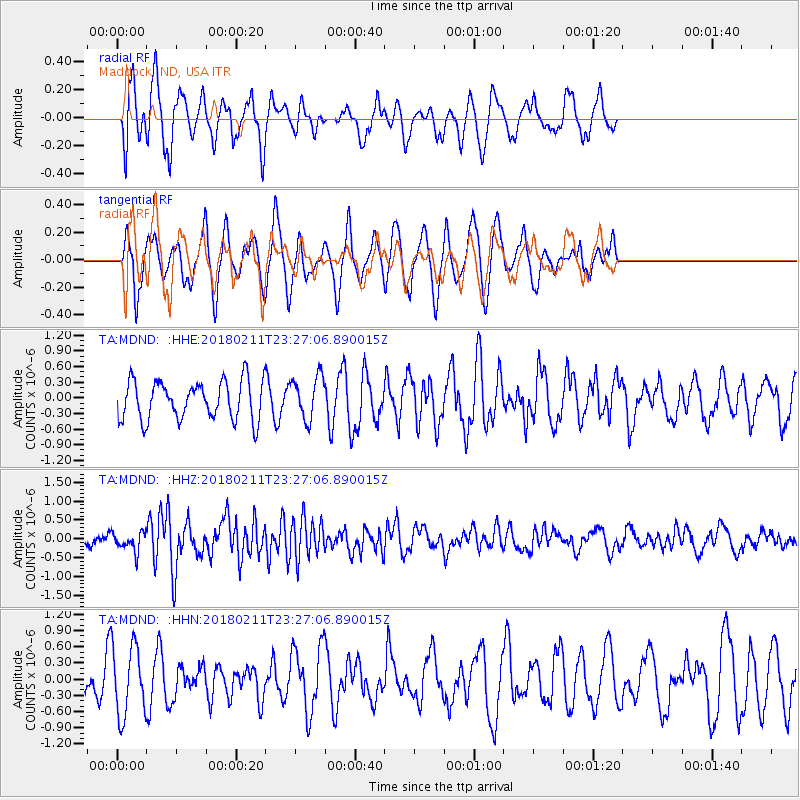
MDND Maddock, ND, USA - Earthquake Result Viewer
*The percent match for this event was below the threshold and hence no stack was calculated.
| Earthquake location: |
South Of Mariana Islands |
| Earthquake latitude/longitude: |
13.8/146.5 |
| Earthquake time(UTC): |
2018/02/11 (042) 23:14:18 GMT |
| Earthquake Depth: |
42 km |
| Earthquake Magnitude: |
6.2 Mi |
| Earthquake Catalog/Contributor: |
NEIC PDE/pt |
|
| Network: |
TA USArray Transportable Network (new EarthScope stations) |
| Station: |
MDND Maddock, ND, USA |
| Lat/Lon: |
47.85 N/99.60 W |
| Elevation: |
479 m |
|
| Distance: |
95.1 deg |
| Az: |
38.199 deg |
| Baz: |
296.901 deg |
| Ray Param: |
$rayparam |
*The percent match for this event was below the threshold and hence was not used in the summary stack. |
|
| Radial Match: |
50.01865 % |
| Radial Bump: |
400 |
| Transverse Match: |
55.37191 % |
| Transverse Bump: |
400 |
| SOD ConfigId: |
13570011 |
| Insert Time: |
2019-04-29 19:32:55.210 +0000 |
| GWidth: |
2.5 |
| Max Bumps: |
400 |
| Tol: |
0.001 |
|
Signal To Noise
| Channel | StoN | STA | LTA |
| TA:MDND: :HHZ:20180211T23:27:06.890015Z | 1.7939662 | 2.52366E-7 | 1.4067489E-7 |
| TA:MDND: :HHN:20180211T23:27:06.890015Z | 2.2638521 | 6.429956E-7 | 2.8402718E-7 |
| TA:MDND: :HHE:20180211T23:27:06.890015Z | 0.8852294 | 3.225279E-7 | 3.6434386E-7 |
| Arrivals |
| Ps | |
| PpPs | |
| PsPs/PpSs | |


