You are here: Home > Network List > TA - USArray Transportable Network (new EarthScope stations) Stations List
> Station N23A Red Feather Lakes, CO, USA > Earthquake Result Viewer
N23A Red Feather Lakes, CO, USA - Earthquake Result Viewer
*The percent match for this event was below the threshold and hence no stack was calculated.
| Earthquake location: |
South Of Mariana Islands |
| Earthquake latitude/longitude: |
13.8/146.5 |
| Earthquake time(UTC): |
2018/02/11 (042) 23:14:18 GMT |
| Earthquake Depth: |
42 km |
| Earthquake Magnitude: |
6.2 Mi |
| Earthquake Catalog/Contributor: |
NEIC PDE/pt |
|
| Network: |
TA USArray Transportable Network (new EarthScope stations) |
| Station: |
N23A Red Feather Lakes, CO, USA |
| Lat/Lon: |
40.89 N/105.94 W |
| Elevation: |
2458 m |
|
| Distance: |
93.8 deg |
| Az: |
46.426 deg |
| Baz: |
291.828 deg |
| Ray Param: |
$rayparam |
*The percent match for this event was below the threshold and hence was not used in the summary stack. |
|
| Radial Match: |
80.36842 % |
| Radial Bump: |
400 |
| Transverse Match: |
61.293674 % |
| Transverse Bump: |
400 |
| SOD ConfigId: |
13570011 |
| Insert Time: |
2019-04-29 19:32:59.466 +0000 |
| GWidth: |
2.5 |
| Max Bumps: |
400 |
| Tol: |
0.001 |
|
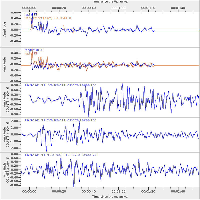
Signal To Noise
| Channel | StoN | STA | LTA |
| TA:N23A: :HHZ:20180211T23:27:01.080017Z | 1.6053299 | 2.0884234E-7 | 1.300931E-7 |
| TA:N23A: :HHN:20180211T23:27:01.080017Z | 0.8713075 | 1.5402074E-7 | 1.7676967E-7 |
| TA:N23A: :HHE:20180211T23:27:01.080017Z | 0.5736794 | 7.448556E-8 | 1.2983831E-7 |
| Arrivals |
| Ps | |
| PpPs | |
| PsPs/PpSs | |


