You are here: Home > Network List > TA - USArray Transportable Network (new EarthScope stations) Stations List
> Station I16A Newdale, ID, USA > Earthquake Result Viewer
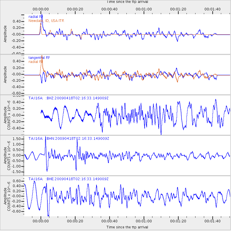
I16A Newdale, ID, USA - Earthquake Result Viewer
*The percent match for this event was below the threshold and hence no stack was calculated.
| Earthquake location: |
Kermadec Islands Region |
| Earthquake latitude/longitude: |
-28.9/-177.4 |
| Earthquake time(UTC): |
2009/04/18 (108) 02:03:52 GMT |
| Earthquake Depth: |
65 km |
| Earthquake Magnitude: |
6.0 MB, 5.8 MW, 5.7 MW |
| Earthquake Catalog/Contributor: |
WHDF/NEIC |
|
| Network: |
TA USArray Transportable Network (new EarthScope stations) |
| Station: |
I16A Newdale, ID, USA |
| Lat/Lon: |
43.88 N/111.49 W |
| Elevation: |
1744 m |
|
| Distance: |
94.2 deg |
| Az: |
41.471 deg |
| Baz: |
233.403 deg |
| Ray Param: |
$rayparam |
*The percent match for this event was below the threshold and hence was not used in the summary stack. |
|
| Radial Match: |
56.634636 % |
| Radial Bump: |
400 |
| Transverse Match: |
55.068993 % |
| Transverse Bump: |
400 |
| SOD ConfigId: |
2658 |
| Insert Time: |
2010-03-06 09:03:50.454 +0000 |
| GWidth: |
2.5 |
| Max Bumps: |
400 |
| Tol: |
0.001 |
|
Signal To Noise
| Channel | StoN | STA | LTA |
| TA:I16A: :BHN:20090418T02:16:33.149009Z | 5.9194064 | 6.6589087E-7 | 1.1249284E-7 |
| TA:I16A: :BHE:20090418T02:16:33.149009Z | 1.7999164 | 4.1866994E-7 | 2.3260522E-7 |
| TA:I16A: :BHZ:20090418T02:16:33.149009Z | 1.131587 | 1.7636802E-7 | 1.5585898E-7 |
| Arrivals |
| Ps | |
| PpPs | |
| PsPs/PpSs | |


