You are here: Home > Network List > GS - US Geological Survey Networks Stations List
> Station DEC05 Decatur Surface Seismic Site, Decatur, IL, USA > Earthquake Result Viewer
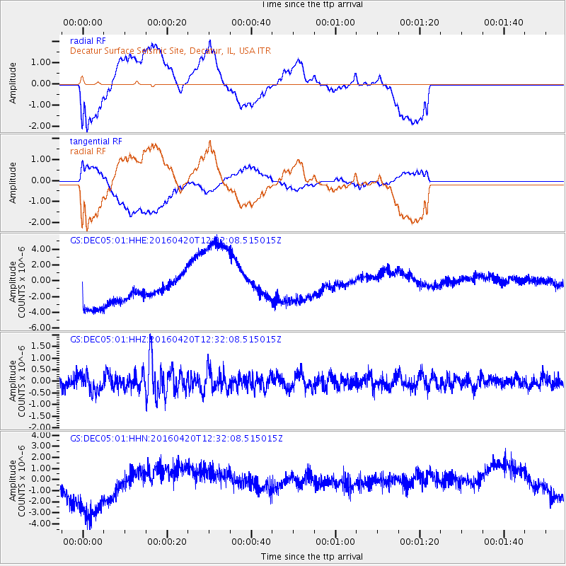
DEC05 Decatur Surface Seismic Site, Decatur, IL, USA - Earthquake Result Viewer
*The percent match for this event was below the threshold and hence no stack was calculated.
| Earthquake location: |
Near East Coast Of Honshu, Japan |
| Earthquake latitude/longitude: |
37.8/141.6 |
| Earthquake time(UTC): |
2016/04/20 (111) 12:19:45 GMT |
| Earthquake Depth: |
41 km |
| Earthquake Magnitude: |
5.8 MB |
| Earthquake Catalog/Contributor: |
NEIC PDE/NEIC ALERT |
|
| Network: |
GS US Geological Survey Networks |
| Station: |
DEC05 Decatur Surface Seismic Site, Decatur, IL, USA |
| Lat/Lon: |
39.87 N/88.87 W |
| Elevation: |
216 m |
|
| Distance: |
89.9 deg |
| Az: |
36.405 deg |
| Baz: |
322.354 deg |
| Ray Param: |
$rayparam |
*The percent match for this event was below the threshold and hence was not used in the summary stack. |
|
| Radial Match: |
13.065645 % |
| Radial Bump: |
400 |
| Transverse Match: |
24.87384 % |
| Transverse Bump: |
400 |
| SOD ConfigId: |
1475611 |
| Insert Time: |
2016-05-04 12:22:10.194 +0000 |
| GWidth: |
2.5 |
| Max Bumps: |
400 |
| Tol: |
0.001 |
|
Signal To Noise
| Channel | StoN | STA | LTA |
| GS:DEC05:01:HHZ:20160420T12:32:08.515015Z | 1.6190276 | 3.7716987E-7 | 2.3296073E-7 |
| GS:DEC05:01:HHN:20160420T12:32:08.515015Z | 4.5607076 | 3.9963684E-6 | 8.762605E-7 |
| GS:DEC05:01:HHE:20160420T12:32:08.515015Z | 4.4158297 | 6.2959953E-6 | 1.4257785E-6 |
| Arrivals |
| Ps | |
| PpPs | |
| PsPs/PpSs | |


